|
Go visit the map archives for a full-size Snake River Plain hill shade
map.
Look at a wide view near Dietrich. CLICK below to explore Snake River Plain geophysical data: |
Terms
& Phrases |
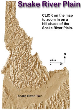
The Snake River Plain is a prominent depression across southern Idaho extending 400 miles in an east-west direction. It is arc shaped with the concave side to the north. The width ranges from 50 to 125 miles with the widest part in the cast. This physiographic province was originally referred to as the Snake River Valley or the Snake River Basin. However, in 1902 F.C. Russell redesignated the province the Snake River Plains. Later the name was changed to Snake River Plain to convey a sense of uniformity throughout the province.
Although the east and west portions of the plain have little relief and are uniform topographically, there are major structural and geophysical differences between the east and west portions of the Snake River Plain.
The subsurface of the plain is known because of thousands of water wells and several deep exploration wells for geothermal resources and oil and gas. Geophysical surveys have also yielded much information on the subsurface.
Many different theories exist for the origin of the plain including a depression, downwarp, graben, and a rift. Although the plain is continuous, the surface geology and geophysical anomalies vary significantly among the western, central and eastern parts of the plain.
Western
Snake
River Plain
The western Snake River Plain is 30 to 43 miles wide and trends northwest. It is a fault-bounded basin with both the land surface and the rock layers dipping towards the axis of the plain. The basin is filled by interbedded volcanic rocks and lake bed sediments of Tertiary and Quaternary age.
The deep wells drilled in the western plain show interbedded basalt and sediment. One well (Anschutz Federal No. 1) about 43 miles south of Boise passed 11,150 feet of alternating sediment and volcanic rocks before it terminated in granite. This granite may be a southern extension of the Idaho batholith.
Geophysical surveys used to interpret the Snake River Plain include gravity surveys, magnetic surveys, seismic refraction profiles, thermal gradient measurements and heat-flow measurements. There is a gravity high over the plain. This gravity high coincides well with the topographic low. The gravity high anomaly over the western plain is interpreted as indicating a thin upper crust. Seismic refraction data also support this interpretation. Seismic refraction profiles indicate that the total crust under the plain is more than 2 5 miles thick; however, the upper crust is thin under the axis of the plain. Heat-now measurements indicate a high heat flow anomaly along the margins of the plain and a relatively low heat flow in the central part of the plain.
Gravity and magnetic anomaly maps suggest several major strike-slip faults offsetting gravity and magnetic features in the plain. All geological and geophysical evidence indicates that the plain is bounded by normal faults. Also, there is no evidence of any pre-Cenozoic rock underlying the plain. It may not be proper to call the Snake River Plain a graben because there is no evidence that pre-Cenozoic rocks exposed north and south of the plain are downfaulted under the plain.
Middle Miocene (15 to
16 m.y. old) rhyolites and alkalic basalts are exposed in the Owyhee Mountains.
These rocks are chemically and isotopically different than those of the Snake
River Plain. North and northwest of Boise, Columbia River Basalt intertongues
with sedimentary deposits of the Payette Formation. Idavada rhyolitic tuffs
and ash flows 15 to 11 million years old were discharged from now buried calderas.
The Idaho Group is composed of fluvial and lacustrine sediments with interbedded
basalt flows deposited in a subsiding basin.
The Idaho Group includes the following formations:
Bruneau formation - 0.7 to 1.3 m.y. old
Glenns Ferry formation - 3 to 4 m.y. old
Chalk Hills formation - 7 to 8 m.y. old
Banbury Basalt - 8 to 11 m.y. old
Poison Creek formation
The Snake River Group consists primarily of basaltic lavas all less than 700,000
years old. Most of the vents of the Snake River Group are east of Twin Falls
in the eastern Snake River Plain.
Central
Snake
River Plain
The central Snake River Plain has a prominent gravity gradient that coincides with a magnetic high; however the margin of the central plain has no well defined topographic expression. Although much of the western plain is covered by sedimentary rocks, much of the central plain is covered by volcanics. The gravity anomaly suggests thinning. The western and central plain appear to have formed from regional tension normal to the trend of the western Snake River Plain.
Eastern
Snake
River Plain
The eastern Snake River Plain trends northeasterly and is underlain by mostly silicic and basaltic volcanic with very little sediments. There is no significant fault control on the margins. The plain rises at the extreme east probably due to the proposed hot spot and associated volcanism recently moving from the Island Park Caldera to Yellowstone.
The land surface is higher at the margins than at the center, similar to the western plain. Both north and south of the eastern plain is the basin and range province with structures aligned approximately normal to the plain. The eastern plain is generally covered by Quaternary basalt flows with sources from fissures parallel to the plain, normal to the plain and along extensions of the basin and range faults.
In the eastern Snake River Plain, the gravity anomalies tend to be higher than surrounding areas. These anomalies exist as random highs and lows with no linear anomaly aligned with the axis of the plain. In fact gravity and magnetic anomalies generally trend normal to the axis of the eastern plain. These elongate anomalies trend northwest-southeast or approximately parallel to the trend of the basin and range.
The Idavada silicic volcanics in the eastern plain are similar to those in the western plain but are younger, ranging in age from 6.2 million years old to 10 million years old. At the northeast end of the plain, the last major eruption of the silicic volcanics is represented by the Yellowstone Tuffs dated at 0.6 to 2 million years old. The Yellowstone Tuffs are associated with caldera collapse followed by copious rhyolite flows erupted as recently as 700,000 years ago.
Large rhyolite domes 0.3 to 1.5 million years old rise above basalt near the axis of the plain. Rhyolite has been found in drill holes and at the margins of the plain. Abundant sediment is also found at the margins of the plain. Gravity and topographic evidence indicate a normal fault at the northwest boundary of the plain.
Caldera Complexes
The Island Park and Yellowstone caldera complexes are situated northeast of the eastern plain. The Rexburg caldera complex on the eastern plain has been identified and the existence of many others has been inferred. The silicic volcanic rocks in and near the Snake River Plain decrease in age from southwestern Idaho to Yellowstone National Park (Armstrong and others, 1975). This may mean that a source or center of silicic volcanics has and is progressively moving northeastward parallel to the axis of the plain. Seismic refraction profiles indicate that the eastern plain and the western plain have a thin upper crust and a thick lower crust. Silicic volcanic rocks and associated intrusive bodies apparently underlie most of the eastern plain. Rhyolite is far more abundant than basalt in the eastern plain - only a thin veneer of basalt lies over a thick sequence of rhyolitic ash and flow tuffs. It is very likely that many source calderas for rhyolite are buried below the basalts.
Island Park Caldera
The Island Park Caldera may be the largest symmetrical caldera in the world. Rhyolite was erupted during the initial collapse period. Then basalt and rhyolite were alternately erupted from vents along the caldera floor. Finally basalt was erupted. The tuffs, flows and fault scarps that make up the morphology of the caldera are so young that they have been modified very tittle by erosion. There were three basic phases in the evolution of the caldera:
1. growth
of the volcano,
2. extrusion
of magma, and
3. collapse.
The Island Park Caldera is an elliptical collapse structure 1 8 to 2 3 miles in diameter and is situated in the center of a rhyolite shield. The western semicircle of the scarp is exposed, and the eastern semicircle is buried under flows of rhyolite. Both basaltic and rhyolitic lava are believed to have originated from a single magma chamber below the caldera.
The rim crest of the southwestern side of the caldera stands about 1200 feet above the plain south of the caldera. The most abundant rock type composing the caldera is flow tuff, followed by ash falls and lava flows. The central portion of the caldera collapsed along a semicircular zone of faults 18 miles in diameter at the western half of the caldera
Tension Fractures
Heat flow in the eastern plain is similar to that in the western plain - low at the center and high at the margins. Many large fractures project inward from the margins of the eastern plain; large flows of basalt have been extruded from them. The fractures must go to sufficient depth to reach molten rock. The fractures are caused by tension parallel to the plain and could be related to regional extension of the basin and range. The Great Rift is one of the most prominent fractures; it includes Craters of the Moon lava fields.
Normal faults of the basin and range are apparently related to overthrusting at depth; evidence indicates that the planes of the normal faults flatten at depth to merge with thrust faults.
Subsidence or Downwarping
The western and central plain may be a downfaulted block something like a rift or graben. The downfaulting may have been caused by regional extension or possible clockwise rotation of a block south of the plain which thinned or parted the upper crust. Gravity and magnetic surveys indicate a thick layer of dense, strongly-magnetized rock formed in the depression. The western and central plains are continuing to subside because of cooling, tension, loading of sediment and isostatic adjustment caused by the dense thick layer beneath the plain.
The central Snake River Plain has features common to the eastern and western plains. Downwarping is the most significant structural activity in the eastern Snake River Plain.
Faults
Volcanic rift zones tend to be oriented along extensions of range-front faults and are caused by east-west extension. Basin and range faults are contemporaneous or younger than the Snake River Plain. These basin and range faults exist both north and south of the plain. This area has been under northeast-southwest extension during the last 17 million years.
Geophysical Characteristics
The entire Snake River Plain is underlain by a 25 mile-thick crust which is anomalously thick. The upper crust is thin relative to the average crust and the lower crust is thick relative to the average crust. Also the upper crust thickens to the east.
The near surface heat flow is relatively high throughout the Snake River Plain and particularly high at Yellowstone National Park. Cold ground water circulating throughout aquifers in the Snake River Plain reduces near surface gradients.
Basaltic Volcanism
The volcanic style of basaltic rocks in the eastern Snake River Plain is gradational between Hawaiian volcanism and flood basalt volcanism. For example, the Roza Member of basalt in the Columbia Plateau is typical of flood basalts. Approximately 350 cubic miles of lava were erupted from an 80-mile-long vent system at the rate of about 0.3 cubic mile per day. By comparison, the Hawaiian and Icelandic-type shield volcanoes are composed of thin flows 10 to 15 feet thick.
Basaltic Lava Flows
Most basalt flows in the Snake River Plains are pahoehoe basalts that were emplaced as compound flows. Compound flows are a sequence of thin individual cooling units ranging from less than 3 feet to more than 30 feet thick. The surface is hummocky with local relief, typically less than 30 feet. Common features are pressure plateaus, pressure ridges, flow ridges and collapse depressions. These features are caused by the way in which flows advance through a series of budding pahoehoe toes. Low areas and swales are filled with wind-blown sediments so that now, on the surface of older flows, only the higher ridges are visible. Aa flows are not as extensive as pahoehoe flows and can best be seen at Craters of the Moon. Basaltic lava is extruded on the Snake River Plain in three ways: flows from a central vent forming low shields, fissure flows and tube-fed flows.
Low Shields
Low shields are characterized by a small size and low profile, They have slope angles of 0.5 degrees and average 10 miles across and less than 1.6 cubic miles of lava. An excellent example is the Wapi lava field.
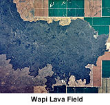
This field covers 116 square miles with compound lava flows of pahoehoe. It is characterized by features such as lava toes, collapse depressions, flow ridges and pressure ridges, but lacks lava tubes. The Wapi lavas have a carbon 14 date of 2,270 years. Many of the low shields have pit craters at the summit and many craters show evidence of collapse. Shields tend to be aligned along rifts or fissures.
Fissure Flows
Fissure vents are associated with rift zones. The youngest fissure flows on the Snake River Plain are located at Kings Bowl and the Craters of the Moon National Monument. Craters of the Moon covers 580 square miles whereas Kings Bowl covers about 1 square mile. Flow thickness is generally less than 5 feet although ponding or lava lakes may cause thicker layers. Point source eruptions along a fissure are common. For example, spatter cones and cinder cones at Craters of the Moon are examples of point source eruptions.
Lava Tube Flows
Lava tubes and channels originating from fissures and low shields are a very major conveyance for the emplacement of lava. These tubes are commonly more than 12 miles long and range from 2 to 30 feet across.
Shoshone Ice Cave is a segment of a complex lava tube - lava channel system, i.e. a system that had both roofed and unroofed segments. Many of the roofed parts later collapsed. The Shoshone lava tube system covers approximately 80 square miles. Smaller subsidiary tubes removed lava from the main tube.
Snake River Group
The Snake River Group includes most of the basalt flows in the Snake River Plains that were extruded during the Pliocene to Holocene epochs. The youngest flows are no more than a few thousand years old and the oldest are about four million years old. Approximately 8,000 square miles of southern Idaho are covered by basalt flows and interbedded sediments of the Snake River Group.
Geophysical studies and drill holes indicate that the plain may be underlain by basalts as much as five miles thick. However 5,000 feet may be an average thickness. Because only the upper 1500 feet were sampled by drill hole, it is possible that some of the basalts not reached by the drill hole are flows of the Columbia River Group.
The Snake River Basalts tend to be extruded from central vents rather than fissures. In the Snake River Plain there are numerous small shield volcanoes 200 to 400 feet high. On a clear day, from almost any place on the Snake River Plain, one can see low hills on the horizon that are either cinder cones or shield volcanoes of basalt. Menan Buttes in western Madison County is an example of a recent cinder cone. At Craters of the Moon National Monument, very recent flows and volcanic structures can be examined.
Look at views of the three landmark eastern Snake River Plain buttes:
* Big
Butte
* Middle
Butte
* East
Butte
Idavada Volcanics
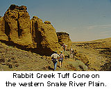
The name Idavada volcanics is applied to a variety of silicic volcanic rocks that crop out in the vicinity of the western Snake River Plain. These silicic rocks include primarily welded ash-flow tuffs; however, also included are vitric tuffs and lava flows. The type locality is Idavada, a place near the intersection of U.S. highway 93 and the Idaho-Nevada State line. Along Goose Creek, a section of silicic tuffs more than 3000 feet thick is exposed. On the north side of the Snake River, a thick section of the Idavada volcanics lies unconformably on granite and makes up most of the Mount Bennett Hills. For example, the scenic Gooding City of Rocks, located in the Bennett Hills, is made up of Idavada silicic volcanic rocks. Pinnacles, bizarre forms and hoodoos are typically formed by differential weathering and erosional processes on the Idavada volcanics. Balanced Rock, south of Twin Falls, is also composed of these volcanics and is a good example of the same weathering phenomenon. The Idavada volcanics also border the southern edge of the Snake River Plain in Cassia, Twin Falls and Owhyee Counties.
The Idavada volcanics are of Miocene age, ranging from 9 to 14 million years old. The flows are oldest in the western Snake River Plain and are consistently younger to the east.
Origin
of the
Snake River Plain
The central and eastern plain is apparently a structural downwarp because strata along the flanks dip towards the center; also there is little evidence for boundary faults. By contrast, the area in the vicinity of Yellowstone appears to be experiencing uplift. This eastward propagation of volcanism may be caused by the migration westward of the continent at a steady rate over a deep mantle plume or hot spot rooted more than 100 miles below the surface. Several hypotheses exist to explain the origin of the Snake River Plain:
1.Extension to the north
coupled with crustal thinning.
2.Migration of the continent or the North American plate over a stationary
hot spot which now exists at Yellowstone National Park. The hot spot has a
northeastward migration of silicic volcanic centers moving at the rate of
1 to 2 inches per year. Uplift is associated with volcanism and silicic volcanism
is followed by basaltic volcanism. The lower crust is thickened and made more
dense by injection of basaltic magma. After passing over the hot spot, the
crust settles due to contraction from cooling and the density of the basalt.
This hypothesis is favored.
3.Propagation of crustal fracture from west to east.
4.Passive deformation.
Geologic
Model
for Snake River
Plain Volcanism
Basalt magma formed in the mantle moves upwards because it is less dense than surrounding mafic mantle rocks. However basaltic rock is denser than crustal rock so the basaltic magma column must extend deep enough into the mantle to allow hydrostatic pressure to force it up through the lighter crust. The basaltic magmas probably originated at a depth of approximately 40 miles. The initial basaltic magmas probably stagnated in the deep crust- however, repeated injection of more magma led to a large magma chamber and a thicker lower crust. During the accumulation of basaltic layers, heat transfer to the crustal wall rocks would cause partial melting (anatexis) of the more silicic crust.
The zone of partially fused wall rocks continues to enlarge as basalt is added. Because partial melts of silicic magmas are less dense than the basaltic magmas, they would tend to coalesce and move higher in the crust to form magma chambers at about 6 miles deep. Intermediate to silicic magmas would continue to differentiate and interact with wall rocks as well as hydrothermal fluids. These magmas would raise the temperature of the crust and the heat would cause the crust to expand and result in regional uplift.
Numerous eruptions of ash-flow tuffs occur during caldera collapse; after collapse, resurgent doming takes place and the cycle is repeated many times. Small rhyolite domes extruded after the main rhyolitic phase represent the residual components of the original silicic bodies. As long as the silicic magma bodies existed as fluids, fissures could not propagate to allow the basaltic magmas to pass. Rhyolitic volcanism ceases with solidification of the silicic magma.
Three
Time
Transgressive Facies
Throughout the Snake River Plain there are three time transgressive facies of volcanic rocks. This means that a similar rock such as the Idavada volcanics is found throughout most of the Snake River Plain but is younger from west to east. These three facies include:
1.Silicic volcanic facies
composed of volcanic sediments, air-fall and ash-flow rhyolite tuffs, rhyolite
flows and subordinate basaltic flows.
2 .Basaltic lava facies with interbedded sediments; a few rhyolite flows and
domes overlap.
3 .An uppermost facies of continental sediments, basaltic lavas, rhyolitic
ash-flow and air-fall tuffs.
Supplemental Material