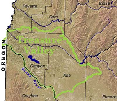
 The Treasure Valley, which
includes the lower Boise River basin and extends south to the Snake River is located
within the northwest-trending topographic depression known as the western Snake
River Plain. The western Snake River Plain is a relatively flat lowland separating
Cretaceous-age granitic mountains of west-central Idaho from the granitic/volcanic
Owhyee mountains in southwestern Idaho. The western Snake River Plain extends
from about Twin Falls, Idaho northwestward to Vale, Oregon. The Snake River Plain
is about 30 miles wide in the section containing the lower Boise River. The depression
is believed to have been formed by crustal extension, beginning as early as 17
million years ago (Malde, 1991).
The Treasure Valley, which
includes the lower Boise River basin and extends south to the Snake River is located
within the northwest-trending topographic depression known as the western Snake
River Plain. The western Snake River Plain is a relatively flat lowland separating
Cretaceous-age granitic mountains of west-central Idaho from the granitic/volcanic
Owhyee mountains in southwestern Idaho. The western Snake River Plain extends
from about Twin Falls, Idaho northwestward to Vale, Oregon. The Snake River Plain
is about 30 miles wide in the section containing the lower Boise River. The depression
is believed to have been formed by crustal extension, beginning as early as 17
million years ago (Malde, 1991).
For geologic information
on the Treasure Valley click on the following links:
Ada County
Canyon County
Elmore County
Gem County
Payette County
Snake River
Plain Geology
Treasure
Valley Geology