Boise
River- Typical July Conditions
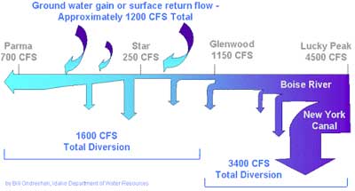
Boise
River Diversions
Boise
River- Typical July Conditions |
|
Boise
River Diversions |
|
Flooding
Annual flooding has been
reduced substantially since the construction of three major dams in the upper
Boise River Basin – Anderson Ranch, Arrowrock, and Lucky Peak. Reservoirs
created by these dams reduce flooding in the lower Boise River and store water
for use during summer irrigation. However, flooding still occurs, from dam releases
under full reservoir conditions and from surface water runoff from tributary
basins in the Treasure Valley. The Federal Emergency Management Agency (FEMA)
is the independent agency of the federal government responsible for protecting
the public when it comes to flooding.
In September of 1999, the Idaho USGS completed a "Restudy of the Boise River Flood Plain in Ada County, Idaho". The USGS surveyed Boise River cross sections and identified existing elevation reference marks. FEMA (Federal Emergency Management Agency) will use this information to update the flood plain and floodway boundaries along a 32 mile stretch of the Boise River from Barber Dam to the Ada/Canyon county line. The Federal Emergency Management Agency -- FEMA -- is an independent agency of the federal government, reporting to the President. Since its founding in 1979, FEMA's mission has been clear:
to reduce loss of life and property and protect our nation's critical infrastructure from all types of hazards through a comprehensive, risk-based, emergency management program of mitigation, preparedness, response and recovery.
Surface
Water Quality
Terms such as effluent trading,
Total Maximum Daily Loads, and run-off are issues that affect the quality of
the Boise River. The Idaho
Department of Environmental Quality and COMPASS
have compiled some reports that summarize the condition of our water resources.
The Idaho Department of Environmental Quality has produced a draft document in pdf format called "Lower Boise River Nutrient Subbasin Assessment". It provides an overview of the Lower Boise River Watershed, including characterization, water-quality concerns, pollution-source inventory, and pollution-control efforts as they pertain to nutrients. (pdf 1.1 Mb, 61 pages)
The Idaho Department Of Environmental Quality report, "Summary of Participant Recommendations for an Effluent Trading Framework (Lower Boise River)" summarizes the efforts of the Lower Boise River Effluent Trading Pilot Project participants, and the recommendations that have emerged for an effluent trading program framework.
"Lower Boise River Nutrient Subbasin Assessment" is a draft document which provides an overview of the Lower Boise River Watershed, including characterization, water-quality concerns, pollution-source inventory, and pollution-control efforts as they pertain to nutrients. Public comment period closed August 17, 2001. (pdf 1.1 Mb, 61 pages).