|
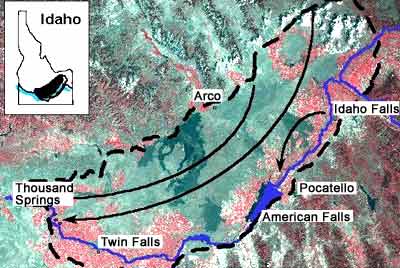
| Flow in the Snake River Plain aquifer is generally from recharge areas in the north and east, to springs in the American Falls and Thousand Springs reaches of the Snake River. |
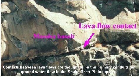
The aquifer is hosted in layered basalts with sediment occasionally deposited between layers. Highly fractured rubble zones at the contacts between layers provide the primary conduit for ground-water flow. The aquifer is considered to be unconfined but may locally respond as a confined aquifer during short duration pumping. This is presumably due to vertical stratification and the presence of lower permeability sediments interbedded among the basalt layers.
Aquifer recharge occurs mainly in the north and east portions of the plain, resulting in generally southwest trending flow lines. Natural discharge from the aquifer occurs primarily along two reaches of the Snake River: 1) near American Falls Reservoir, in which spring discharges total about 2,600 cfs; and 2) in the Kimberly to King Hill reach (Thousand Springs reach), where the collective discharge is about 5,200 cfs.
During summer, the spring flows provide the majority of the flow in the Snake River below the irrigation diversions of Milner Dam. The Snake River basin contains 15 of the Nation's 65 first magnitude springs (discharge greater than 100 cfs).
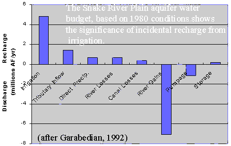 The
graph to the left is a water budget for the Snake River Plain aquifer representing
1980 conditions. Surface water irrigation is by far the largest component
of aquifer recharge, with smaller contributions from tributary valley underflow
and seepage from rivers. During the past several decades, ground water
storage has been depleted, causing water levels to drop.
The
graph to the left is a water budget for the Snake River Plain aquifer representing
1980 conditions. Surface water irrigation is by far the largest component
of aquifer recharge, with smaller contributions from tributary valley underflow
and seepage from rivers. During the past several decades, ground water
storage has been depleted, causing water levels to drop.
Variations in weather patterns and changes in irrigation practices on the Snake River Plain have caused changes in aquifer water levels. The linked map (*click here to view) shows changes in water levels from Spring 1980 to Spring 1998. Some areas of the aquifer have experienced drops in water levels where other areas have experienced slight increases in water levels.
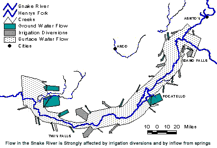
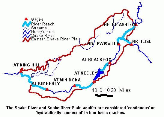
One of the major concerns of conjunctive management is the identification of river reaches or surface water bodies that are hydraulically interconnected with an aquifer. The conceptual basis for this concern is described in the section on "Surface Water and Ground Water Interaction". In some cases it is difficult to determine the degree of interconnection because of uncertainties in river bottom conditions and water table depth and because conditions vary with time. A river reach that at one time is hydraulically connected to the aquifer may be perched at another time when aquifer water levels are lower. The State's computer model of the Snake River Plain aquifer treats four major reaches (bounded by gaging stations) of the Snake River as interconnected with the aquifer (see illustration).
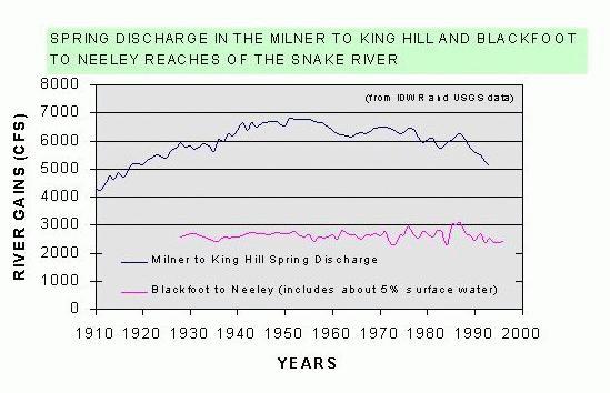
1) The Kimberly to King Hill reach (Thousand Springs reach), in which the river is deeply incised in a canyon and springs discharge along the canyon wall and in the bottom of the river. Total spring discharge in this reach is about 5,200 cfs. The discharge in this reach varies seasonally and also has shown long term variations reflecting weather and irrigation patterns.
2) The Neeley to Minidoka reach which may alternately gain and lose water depending upon water table elevation. The U.S. Geological Survey estimated that this reach had a net gain of 180 cfs in 1980 (Garabedian, 1992).
3) The Blackfoot to Neeley reach in which springs contribute about 2,600 cfs to the flow of the river. Spring discharges in this reach exhibit seasonal variation (graph), but have not shown the long-term variation like the Kimberly to King Hill reach (graph). The reason for the long-term stability in this reach is not known.
4) The Henrys Fork and Upper Snake River reaches which were estimated to jointly gain approximately 260 cfs in 1980 (Garabedian, 1992).
Changes in water table elevation, due to natural causes or man caused activities, result in changes in river gains and losses in these reaches. Although the effects of ground water pumping cannot be measured or separated from effects of natural events, ground water models can provide estimates of individual and collective pumping effects.