 The
Snake River is perhaps most well known for its recreational features such as
world-class fishing, white water rafting, and the many lakes and reservoirs
with excellent opportunities for boating, camping and fishing.
The
Snake River is perhaps most well known for its recreational features such as
world-class fishing, white water rafting, and the many lakes and reservoirs
with excellent opportunities for boating, camping and fishing. The
SR3 study area includes that portion of the Snake River Basin which is upstream
of Brownlee Dam. As seen on the adjacent map, the drainage area associated with
the Snake River in this study covers portions of five states: Wyoming, Idaho,
Utah, Nevada, and Oregon. The Fort Hall (Shoshone-Banock) and the Duck Valley
(Shoshone-Paiute) Reservations are also located in the area. The drainage basin
includes over 72,000 square miles.
The
SR3 study area includes that portion of the Snake River Basin which is upstream
of Brownlee Dam. As seen on the adjacent map, the drainage area associated with
the Snake River in this study covers portions of five states: Wyoming, Idaho,
Utah, Nevada, and Oregon. The Fort Hall (Shoshone-Banock) and the Duck Valley
(Shoshone-Paiute) Reservations are also located in the area. The drainage basin
includes over 72,000 square miles.
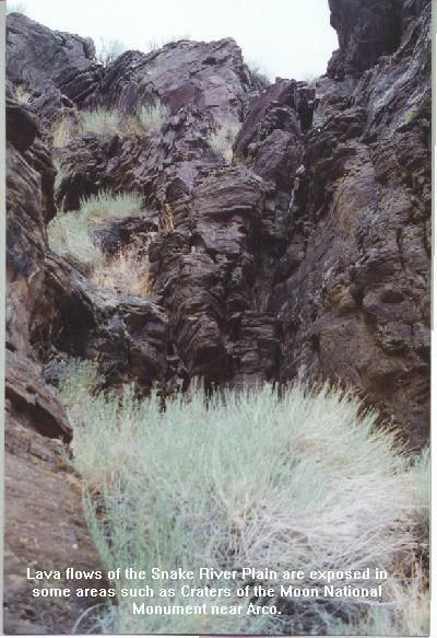
The area includes rugged mountains, semi-arid desert, fertile agricultural land (primarily irrigated), and barren outcrops of lava flows. Most of the famous "Idaho potatoes" are grown in the irrigated portions of the Snake River Plain, but range, lava flows, and timber are the dominant land covers in the basin. Pine and spruce forests inhabit the higher elevations. Most of the land in the basin is owned by the Federal Government (U.S. Forest Service, U.S. Bureau of Land Management, and U.S. Department of Energy).
One of the most prominent physiographic features of the basin is the Snake River Plain. This curved topographic feature extends across southern Idaho into eastern Oregon. The Snake River Plain is approximately 350 miles long and varies in width from 30 to 75 miles. The Plain is discussed in more detail in "Origin of the Snake River Plain" and the "Eastern Snake River Plain".
The Snake River is the dominant hydrologic feature of the basin and is the only river discharging from the area. The Snake extends from its source in Jackson Lake, Wyoming, to its confluence with the Columbia River in Washington. This discussion, however, is limited to the portion above Brownlee Dam. To travel down the Snake River from Jackson Dam to Brownlee Reservoir is a journey of over 700 miles.
Along the way, the Snake and its tributaries tumble over spectacular waterfalls, meander through deep and scenic canyons, and provide the water for irrigating millions of acres of agricultural land.
The
Snake River is perhaps most well known for its recreational features such as
world-class fishing, white water rafting, and the many lakes and reservoirs
with excellent opportunities for boating, camping and fishing.
The Snake River has many tributary streams that are important components of the river system. The tributaries provide a means of collecting the precipitation that accumulates in the mountains surrounding the Snake River Plain. Water collected in the tributaries, enters the Snake River directly as surface flows, evaporates, or infiltrates into the subsurface where it later enters the river as spring flows.
Fifteen of the Nation's 65 class one springs (greater than 100 cubic feet per second discharge) are in the Snake River basin. These springs support fish hatcheries that produce the majority of the Nation's commercial trout and produce juvenile fish for planting in lakes and streams.
The amount of natural flow in most of the streams varies throughout the year due to the annual cycle of precipitation. Water accumulates during the winter snowfalls and is released by spring melting of the snow pack. The normally hot dry periods of late summer and early fall are additional factors driving the cyclic nature of flow volumes. In many locations the annual variation in stream flow volume is altered depending on the operational needs of the many reservoirs that have been constructed within the system.
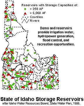
The Snake River and its tributaries, including the aquifers that make up the ground water system, provide water for many uses including: agricultural use, municipalities, industrial and domestic uses, recreation, Native American cultural needs, and habitat for fish and wildlife. The U.S. Bureau of Reclamation, along with other state and federal agencies and private groups, is attempting to manage the water resources of the basin for the many, and sometimes competing, uses. The Snake River Resources Review (SR3) is an effort to take an integrated look at all uses and needs and provide managers with the tools and information necessary to make informed and reasonable decisions. The water resource, and consequently the information, must cross the boundaries of five states and two Indian reservations.