Snake River
Plain -The Importance of Tributary Basins to the Snake River
 |
|
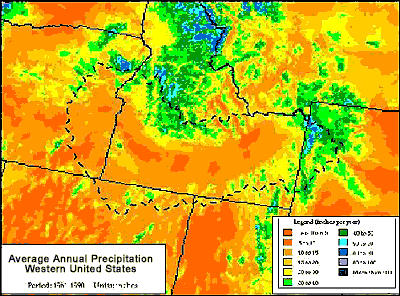
figure
9. PRISM average annual precipitation map with SR3 outline (after Daly
1998).
Image by Oregon State University.
|
While the flow of water within the Snake River receives a tremendous amount of
attention, it is necessary to take a closer look at the areas where the flow originates.
Precipitation is the sole source of recharge in tributary basins. The Oregon Climate
Service (Daly, 1998) created an average annual precipitation map for the Western
United States covering the time period 1961-1990 (see map to left). This map shows
that within the Snake River Plain precipitation is less than 15 inches per year
with some areas receiving less than 10 inches per year. Precipitation totals in
the tributary basins can exceed 60 inches per year. These maps were created using
the Parameter-Elevation Regressions on Independent Slopes Model (PRISM). To see
Idaho's average annual precipitation map click
here.
Two factors stand out as reasons to include tributary basins when discussing
the flow of water within the Snake River. First, the majority of recharge occurs
within the tributary basins. Second, the large areas associated with the tributary
basins provide opportunities for development and use of water within the tributary
basins themselves. Use of water within a tributary basin can affect the quantity
and timing of water availability to the Snake River.
Information supplied
by Idaho Water Resource Research Institute, University of Idaho December 1998
Authors: Dr. Gary Johnson, Donna Cosgrove, and Mark Lovell.
Graphics: Sherry Laney and Mark Lovell
All State of Idaho images and graphics created with GIS files obtained through
Idaho Department of Water Resources Public Domain GIS unless otherwise noted.
Source
Information