figure
1
|
|
figure
1
|
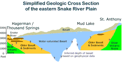
Although the total thickness of basalts is estimated to be more than 5,000 feet (figure 1), groundwater flows most rapidly in the upper 300 - 500 feet, which is the most productive portion of the aquifer. Interconnected pore spaces in the rubbly tops of lava flows transmit water very readily, and well yields above 3,000 gallons per minute are not uncommon.
Total ground-water storage in the upper 500 feet of the aquifer is estimated at 200 to 300 million acre-feet, roughly the equivalent of Lake Erie.
 The
direction of ground water flow in the upper part of the aquifer is generally
from east-northeast to west-southwest.
The
direction of ground water flow in the upper part of the aquifer is generally
from east-northeast to west-southwest.
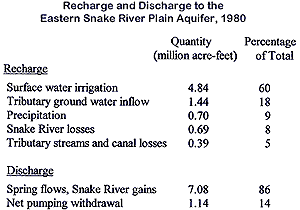
Human activity has had a tremendous impact on the water balance of this aquifer. About sixty percent of total recharge to the aquifer is derived from irrigation with surface water (figure 2). Most groundwater still leaves the aquifer via springs and seepage losses in two major upper basin reaches, although pumping withdrawals contribute significantly to the aquifer’s total losses.
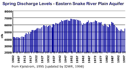
Irrigation practices have and continue to exert a major influence on water resources of the Eastern Snake River Plain. Prior to 1950, spring discharges (figure 3) and the water table between Kimberly and Bliss rose by 60-70 feet on average during the period 1907-1959, accounting for a cumulative increase of more than 5 % of the aquifer’s total storage.
 |
|
figure
3
|
During the 1950s and 1960s more land began to be irrigated with groundwater and irrigation efficiency increased through the use of sprinkler irrigation and conservation. The result was a substantial decline in groundwater levels in parts of the Plain between 1975 and 1995, leading to a cumulative decrease in aquifer storage of about 3 %, and decreased spring flows between Kimberley and Bliss (figure 3).
In general, the declines in spring discharge and ground water levels have been due to increased groundwater pumping, more efficient irrigation methods, and reduced reliance on surface water diversions for irrigation. However, localized declines may be predominantly the result of increased pumping withdrawals in some areas.