 |
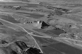
| Aerial view looking north at Red Rock Pass. The dam to Lake Bonneville consisted of coalesced alluvial fans which nearly covered Red Rock Butte. According to D.E. Fortsch, (ISU Geology Department), Lake Bonneville water may have leaked through underground (karst) caverns in the Butte and controlled the lakes highest level. A post-flood earthflow can be seen on the left of the photo, (April, 1992). From Rocks, Rails and Trails. |
The Bonneville Flood was one of these ancient catastrophic floods that occurred approximately 14,500 yrs. ago, the result of catastrophic failure of one of the natural dams at Red Rock Pass of Pleistocene Lake Bonneville.
Pleistocene Lake Bonneville covered most of Utah and parts of Idaho and is estimated to have been over twelve times greater in size than the modern Great Salt Lake. When the dam broke, the flood waters involving approximately 4,750 km3 of water, traveled at an estimated 45 miles/hour, carrying 935,000 yds3 of water/sec. eroding the Snake River Canyon to over 500 ft. deep and over a mile wide in some places.
This catastrophic event changed the landscape of the Snake River Plain to what we visibly see today. Several geologic features that resulted from this spectacular event including large bar complexes, fine-grained slack water deposits, scoured and eroded basalt and scabland topography are visible along the flood route.