|
|
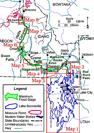
The Bonneville Flood was one of these ancient catastrophic floods that occurred approximately 14,500 years ago (O’Connor, 1993); the result of catastrophic failure of one of the natural dams at Red Rock Pass of Pleistocene Lake Bonneville.
Pleistocene Lake Bonneville covered most of Utah and parts of Idaho and is estimated to have been over twelve times greater in size than the modern Great Salt Lake. When the dam broke, the flood waters involving approximately 4,750 km3 of water, traveled at an estimated 45 miles/hour, carrying 935,000 yds3 of water/second, eroding the Snake River Canyon to over 500 ft. deep and over a mile wide in some places.
It is estimated that it took about 20 days for most of the water to empty the majority of water in the lake.
This catastrophic event changed the landscape of the Snake River Plain to what we visibly see today. Several geologic features that resulted from this spectacular event including large bar complexes, fine-grained slack water deposits, scoured and eroded basalt and scabland topography are visible along the flood route (Malde, 1968 and O’Connor, 1993).
Click on the image or
links below to see the information of that area.
Map 1- Lake
Bonneville to Red Rock Pass
Map 2- Red
Rock Pass to Pocatello
Map 3- Raft
River to Kimberly
Map 4- Twin
Falls to Glenns Ferry
Map 5- Swan Falls to Walters
Ferry
Map 6- Weiser
to Brownlee Reservoir
Map 7- Johnsons
Bar to Dug Bar
Map 8- Grande
Ronde to Clarkston