|
Page153
|
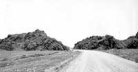
(left) U.S. Highway 30 before it was paved (about 1930 or 1931), passing west through Massacre Rocks. The roadway was widened in the late 1930s and again in the late 1980s. Most of the rocks to the left of the road are gone. The Oregon Trail is just off the picture to the right. The 1862 massacre is generally thought to have been near here. Photograph by Cook Photography, Bannock County Historical Society Collection.
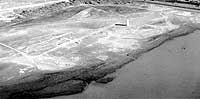
(center) Aerial view of Old American Falls townsite, looking southeast, (September, 1988). Note the grain elevator, the layout of the old streets, and the old foundations. The former railroad right of way slants to the south, east of the elevator. The town was moved in 1926 during construction of the present dam. At the time of this photo the reservoir water had been drained by irrigation to near its lowest permissible level.
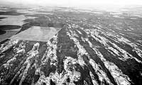
(upper right) Longitudinal dunes on the Snake River Plain northwest of American Falls. The dunes are shaped by the prevailing southwest wind along the axis of the Snake River Plain, (September, 1988).
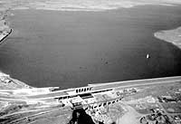
(right) View looking northeast at American Falls Reservoir at about maximum level, (May, 1989). Note the grain elevator of the old town of American Falls poking through the waters of the lake.