Page
145
|
Page
145
|
|
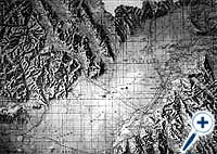
| Shaded relief map of the Snake River Plain. Click on image for a larger view. |
|
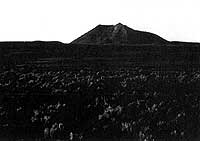
| East Butte, a 600,000 year old rhyolite dome, looking east from Highway 26, (July, 1991). |
Toponce
Stage Line and Root Hog
In 1878,
a stage line was established by Alexander Toponce, who had previously begun
a cattle business in the Northern Portneuf Range.The stage ran from Blackfoot
to the copper mines near Houston (mackay), and north to Challis.
A stage station northeast of the Big Butte tapped a spring on the side of the Butte that was the only reliable water source between the Snake River and the Big Lost River. In the 1880s, the proprietors reportedly let pigs run loose at the stage stop to keep down the rattlesnakes.
Half way from the Snake River to the Big Butte stage stop was another station known as "Root Hog or Die," later shortened to Root Hog. Water was hauled to Root Hog from the Big Butte by the stage company.
|
On June 25, 1887, the Idaho News of Blackfoot reported that:
|