Page
107

|
Page
107
|
|
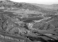
| Aerial view of Portneuf Narrows from the west. Into the narrow gap are crowded the meandering Portneuf River, following the broad path of the Lake Bonneville Flood, the main line of the Union Pacific Railroad, Interstate 15 and the Bannock Highway on the south side of the river. In this locality, the Lake Bonneville Flood was about 300 feet deep. This gap was its narrowest constriction. In the distance is the Portneuf Range, with the high point Mount Bonneville. On the left of the Narrows is the south ridge of Chinks Peak. The Portneuf Narrows tear fault runs through the straight gully immediately left of the scar of the roadcut on the Interstate highway, (June, 1989). |
The
Gateway to the Northwest
The narrow
canyon of the Portneuf River through the Bannock Range between Inkom and Portneuf
Narrows is the geographic key to the development of southeast Idaho and the
city of Pocatello. It was this water-level route that became the Idaho Gold
Road followed by stages and freighters from 1864 to 1878, and then the route
of the Utah & Northern and the Oregon Short Line railways. This was not,
however, the route followed by the Oregon Trail.
The canyon was probably cut by the ancestral Bear River, on the order of a million years ago, in response to the subsidence of the area of the Snake River Plain near Pocatello after passage of the ancestral Yellowstone Hot Spot.
The canyon follows a line of weakness along the east-west Portneuf Narrows tear fault that probably formed in Cretaceous time during folding of rocks of the Putnam thrust plate. This tear fault passes north of the Portneuf River at Portneuf Narrows and separates rocks of the Late Proterozoic Pocatello Formation to the north and underlying Chink's Peak, that are structurally overturned, from correlative strata on the south side of the fault that are right-side-up.
The rocks exposed between the west side of Portneuf Narrows and Inkom span about 250 million years of earth history, that is from Late Proterozoic to Upper Cambrian time (750 to 500 million years ago). They thus were deposited during the development of complex invertebrate life forms which appeared on earth between about 610 and 540 million years ago. Several of the references cited at the end of this section discuss the complex geology of the Portneuf Narrows area.
 |
 |
|
(left) Column of basalt lava from the Basalt of Portneuf Valley near Inkom. Dark holes in the lava are vesicles or gas bubbles which exsolved out of the molten basalt. Basaltic lava tends to cool to six-sided columns as it shrinks during the change from liquid to solid, (June, 1989). (right) Portneuf Narrows from the southeast, looking west to Pocatello,(July, 1990). Gibson Mountain is on the horizon at the left, and Howard Mountain on the far horizon at the right. Late Proterozoic rocks of the Pocatello Formation are present north of the Gap, on the overturned limb of a large fold. Rocks of the same age on the south side of the gap are right-side up. The boundary is the Portneuf Narrows tear fault, which cuts through the small saddle about 1/3 of the way up the slope on the north side of the gap. |
|
Drainage
History
In the
Miocene, about 8 million years ago, the Yellowstone Hot Spot was located near
Pocatello. The Pocatello-Blackfoot area was a high volcanic plateau, and drainage
in the Inkom area was probably to the south. After the Hot Spot migrated northeastward
and the former high plateau subsided, the direction of drainage was reversed.
This was when the Portneuf Narrows was cut, by the ancestral Bear River. The
gap was cut when streams began to flow north to what became the west-flowing
Snake River, draining west in the wake of the east-migrating Hot Spot.
The floor of the Narrows had been lowered by 600,000 years ago to near the level of the present valley floor. Basaltic volcanic activity in Gem Valley, near present-day Bancroft, produced the Basalt of Portneuf Valley, which flowed down this canyon for about 50 miles, through the Narrows and to what is now Ross Park in Pocatello. Two lava flows can be distinguished.
The Bear River was diverted by these or associated volcanic eruptions to flow south into southern Gem Valley, and eventually to cut a passage at Oneida Narrows into the Lake Bonneville basin. The Portneuf River is thus the remnant of the ancestral Bear River.