|
Page
43
|
|
||
|
||
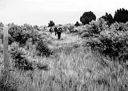
| Oregon Trail ruts southeast of Chesterfield, (October,1986). |
The
Oregon-California Trail
The Oregon-California
Trail was around 2,200 miles long. Beginning around 1840, it departed from points
along the Missouri River, such as Independence and St. Joseph, Missouri, and
Omaha, Nebraska. In the early years, before the trail was improved and bridges
were built, the trip took 4 to 6 months, depending on the weather, difficulties
along the way, the experience of the travelers or their guide and so forth.
In later years, the trip took somewhat less time.
Departure dates depended mainly on the weather. Teams could not travel until grasses began growing for feed. The ground had to be dry enough so the loaded wagons would not sink into mud. But the trip had to begin as early as possible so that the Sierra Nevada, the Blue Mountains and the Cascades could be crossed before winter snows caught the travelers. Departure was usually between mid-May and early June, depending on whether the spring was dry or wet.
The limitations imposed by the finite pulling power of draft animals tended to cause the Trails to follow water routes where possible. The relatively easy grade and open nature of the country at South Pass, Wyoming, the principal pioneer crossing of the Continental Divide, simplified the passage between the watersheds of the Atlantic and the Pacific.
In open areas, wagons could fan out over a broad area to avoid traveling in the dust of those in front, but in hilly areas this was not possible. Until brakes were put on wagons in the 1850s, steep descents were a problem. Sometimes ropes were used to lower each wagon or wheels would be chained so the wagon could slide down the grade. Runaway wagons were one of the many hazards of the trip, with damage to the loads and injury to passengers and draft animals.
Until 1847, the travelers were mainly settlers headed for Oregon. The Mormon emigration, led by Brigham Young to the promised Zion in Utah, started that year. The California Trail was lightly traveled until after the discovery of gold in 1848. Starting in 1849, travel greatly increased, most of it headed for the gold fields. One author estimates that between 1840 and 1860, the principal years of the trails, 300,000 people made the trip west, with approximately 47,000 Mormon Pioneers going to Utah, approximately 53,000 farmers ending up in Oregon and around 200,000 gold seekers traveling to California.
The Oregon-California Trails were not the only routes taken by pioneers. More persons traveled to California by other routes, overland along the Santa Fe Trail through the southwest deserts, by roads through central America and by ship to Panama or around Cape Horn.
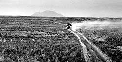 |
| Following the Goodale Cutoff north toward the Big Butte. Photo taken south of Root Hog, (June, 1990). |
Trail
Routes
After the
Oregon Trail negotiated South Pass, a variety of routes and cutoffs was utilized.
Some pioneers followed the main, or original Oregon Trail across the Green River
to Fort Bridger, near Evanston, Wyoming, then down the Bear River past Soda
Springs, Idaho. Others took the Sublette Cutoff, a shorter but drier route reaching
the Bear River in the vicinity of Cokeville, Wyoming. A few miles west of Soda
Springs, at Sheep Rock (also called Soda Point), the Oregon and original California
Trails headed northwest across Gem Valley. The trails crossed the headwaters
of the Portneuf River north of what was to become Chesterfield, rounded the
north side of North Putnam Mountain, and dropped down past Big Springs to the
Snake River bottoms and the area of Hudson's Bay Company trading post of Fort
Hall.
Hudspeth
Cutoff
Beginning in 1849,
most of the California-bound pioneers utilized Hudspeth's Cutoff, which departed
from the main Oregon-California Trail by heading straight west at Sheep Rock.
Hudspeth's Cutoff wound through mountainous country north and west of present-day
Malad City before rejoining the California Trail on the west side of the Raft
River Valley on Cassia Creek near the present day town of Malta. Hudspeth and
his fellow guide Myers felt their route would save over one hundred miles. In
fact, the route eliminated only around 25 miles and there was no saving of time.
On top of that, the much more difficult Hudspeth route had less water and feed
and was harder on animals and equipment. Nevertheless, thousands of Americans
yet to come, true to their national temperament, would take the cutoffs, believing
that by going west rather than northwest they would be able to get ahead of
others and reach California first.
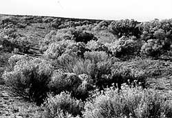 |
| Robust growth of sage and rabbitbrush along the Oregon Trail near Milner Dam, east of Twin Falls, (October, 1992). |