|
Page
30
|
|
||
|
|
||
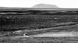
| View looking south from Howe Point at the south end of the Lemhi Range to the Sinks of the Big Lost River and the Big Southern Butte in the background (June, 1996). This was a wet spring and there is a great deal of water both flowing in the rivers and standing ponds in the sinks area. Although it is not obvious, the entire flat area between the cows and the dark escarpment, is covered with standing water. | ||
|
|
||
| Big Lost River Rest Area, U.S. Highway 26, (July, 1993) |
Lake
Bonneville Flood
The catastrophic Lake Bonneville
Flood occurred about 14,500 (radiocarbon) years ago. The Lake Bonneville Flood
was about 3,000 years after the Big Lost River floods and the Lake Missoula
floods (rathburn, 1993, O'Connor and Baker, 1992). The point of outflow was
at Zenda, a few miles north of Red Rock Pass, between Swan Lake and Downey,
at the north end of Cache Valley. The flood carried the upper 350 feet of water
in Lake Bonneville northward through Marsh Valley to Pocatello and the Snake
River, and lowered the lake to the Provo shoreline level (4,740 feet), the level
of bedrock at Red Rock Pass (malde, 1968). The total volume of the Lake Bonneville
Flood is estimated to have been 4,750 cubic km (or 1,150 cubic miles) of water,
with a peak discharge lasting about 8 weeks (Jarrett and Malde, 1987; O'Connor,
1990, 1993). The peak flow was about one million cubic meters per second at
Red Rock Pass. This flow is around 500 times the maximum discharge of the Snake
River ever recorded at Idaho Falls. For comparison, the average discharge of
the Amazon River is 170,000 cubic meters per second. The topography
left behind by the flood is called scabland topography and is manifested in
dry waterfalls, alcoves, scoured bedrock surfaces and Boulder bar accumulations
along the flood path.
The cause of the flood is not known. One possibility is that an earthquake of the Intermountain Seismic Belt weakened part of the alluvial fan material that was serving as the dam to the lake. Another possibility is that the leaking water simply eroded its own piping system which undermined the overlying gravel.
After the flood, the lake stood at the Provo shoreline (4,740 feet) until about 13,000 years ago. It filled the lower portions of Cache and Malad Valleys and had an outlet, north into Marsh Creek. When the climate began to rapidly become drier, the lake began to recede, and the Great Salt Lake, at most 40 feet deep, is the modern remnant. The present lake level was reached by about 11,500 years ago.
The rise and fall of the lake caused changes in streams that entered it. When the lake stood at the Bonneville level, it reached as far north as Grace, in Gem Valley. At the Provo level the shoreline was farther south, near Preston. The gradient and speed of water flow in Bear River was drastically changed by these levels. The wide Bear River canyon at Preston has been eroded since the retreat below the Provo level, only 13,000 years ago.
After passing north from Red Rock Pass to Marsh Valley, Portneuf Narrows and Pocatello, the flood emptied into a flat area along the Snake River which had been occupied, about 70,000 years ago, by the ancestral American Falls Lake. Water ponded here and then flooded down into the Snake River Canyon near Massacre Rocks. This flood scouring produced the abandoned "Lake Channel," north of Massacre Rocks.Disposal
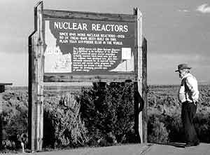
of Wastes at the Idaho National Engineering & Environmental Laboratory
At the INEEL,
the water table is 200 to 1000 feet below the ground surface, though its elevation
is observed to change from wet to dry years by at least 80 feet. The groundwater
flows at a rate of 5 to 20 feet per day through layers of basalt lava and rubble
zones between the flows. The aquifer has a distinct top (above which the rock
is not saturated, and bottom (below which the permeability is apparently too
low to allow water to flow).
Disposal of radioactive wastes at the INEEL has not harmed the water quality in a major way. Traces of radionuclides have been detected in the aquifer south of the INEEL, having migrated up to 7.5 miles in 20 years. Injection wells which discharged waste water used for cooling nuclear reactors were operated from 1953 to the mid 1980s. A plume of tritium, or heavy hydrogen, had migrated past the edge of the INEEL by 1985, but has begun to shrink since the injection wells were closed down. Only natural background levels of radiation are detectable at the Thousand Springs area west of Twin Falls.
All this is not to say that nuclear waste disposal at the Idaho National Engineering Laboratory must not be closely monitored. Indeed, Idaho politicians should consider the effects of federally funded nuclear waste disposal on tourism and quality of life in southern Idaho. We probably would not gain from a change in the state motto to "Idaho Famous Waste Dumps."
As of October 1991 a Department of Energy report revealed that the following nuclear waste inventory existed for the entire INEEL:
- Spent Fuel 700 metric tons
- High-level nuclear waste 423,000 cubic feet
- Low-level nuclear waste 5,088,891 cubic feet
- Stored transuranic waste 1,323,323 cubic feet
- Buried transuranic waste 2,016,486 cubic feet
- Contaminated soil 1,977,6405,509,140 cubic feet