|
Page
28
|
|
||
|
||
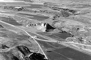
| Aerial view looking north at Red Rock Pass. The Butte in the center of the valley is underlain by Cambrian limestone. The headwaters of Marsh Creek drain directly south, toward the camera and then turn 180o and head north into the freshly excavated flood channel. The dam to Lake Bonneville consisted of coalesced alluvial fans which nearly covered Red Rock Butte. According to D.E. Fortsch, (ISU Geology Department), Lake Bonneville water may have leaked through underground (karst) caverns in the Butte and controlled the lakes highest level. A post-flood earthflow can be seen on the left of the photo, (April, 1992). |
The
Rise of Lake Bonneville
Although lakes
had existed in the Bonneville Basin periodically for 15 million years, the largest
and deepest of these existed only 30,000 to 14,500 radiocarbon years ago, and
it is this lake that we refer to as "Lake Bonneville."
The rise of Lake Bonneville was caused by both climatic change and the diversion of the drainage of the Bear River into the Bonneville Basin. The Bear, which comprises about a third of the fresh water input into the Great Salt Lake today, had formerly flowed into the Snake River, possibly through the present canyon of the Portneuf River at Pocatello.
The Bear River was diverted south, into southern Gem Valley, by basaltic volcanic eruptions near Bancroft around 600,000 years ago. These eruptions also produced the Basalt of Portneuf Valley, which flowed down the Portneuf River canyon through Lava Hot Springs, Marsh Valley, Inkom, and Pocatello. The diversion of the Bear through Oneida Narrows and into the Bonneville Basin and the cool climates of the most recent (Pinedale or Wisconsin) glacial period, caused the rise of Lake Bonneville.
Lake Bonneville rose from near the modern level of Great Salt Lake today (4210 feet) at 30,000 years ago to the Bonneville Shoreline at 5090 feet about 17,000 years ago. At Red Rock Pass, the lowest point on the lake margin, alluvial fans from the adjacent Bannock and Portneuf Ranges had coalesced above bedrock of Cambrian limestone. As Lake Bonneville rose, leakage of water through the alluvial fan gravels plus though caverns in the limestone possibly controlled the level of its maximum shoreline at 5090 feet.
In southeastern Idaho, Lake Bonneville occupied the entire Cache Valley, the extreme southern end of Gem Valley, much of Malad Valley, and the area around Holbrook and Stone.
Shorelines
and Canals
The Mormon Pioneers
took full advantage of the ancient shorelines of Lake Bonneville and built their
towns and irrigation canals along them. It was as if the area had already been
leveled and surveyed!
 |
 |
|
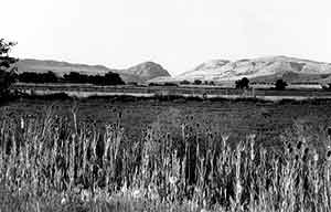
(left) Lake Bonneville shorelines near Brigham City, Utah. The Bonneville level is the upper one, at about 5090 feet. The next prominent level is the Provo shoreline at about 4,740 feet, which the lake occupied for a few hundred years before retreating toward its present level, (July, 1982). (right) Bear River Narrows looking east from near Garland, Utah. The Lake Bonneville shoreline is the level of the top of the grain fields. Through this narrow canyon Lake Bonneville emptied into Cache Valley as its flood was pouring down through Red Rock Pass into Marsh Valley. Today the main north-south line of the Union Pacific Railroad winds through the narrow canyon at Cutler Dam, (May, 1983). |
|