|
|
|
|
Established in 1988
* View
Location Map
* Visit the
Reserve Web Site
The "Silent City of Rocks" covers a 10-square mile area in Cassia County, approximately 4 miles from the Idaho-Utah border. It is situated 15 miles southeast of Oakley and about 4 miles west of Almo. You can reach the City of Rocks by traveling through Oakley on the west or through Almo on the east; both routes involve travel on graded gravel roads.
The City of Rocks has been designated as a natural and historic national landmark and is under study by the Bureau of Land Management and the National Park Service for inclusion in the park system. The major obstacle to establishing better protection and management of the area is the mixed ownership. The Forest Service administers 1,120 acres; the Bureau of Land Management administers 1,040 acres, 640 acres is owned by the State of Idaho; and the remaining 4,000 acres is in private ownership.
History
Shoshone-Bannock tribes hunted the buffalo that once roamed in the City of Rocks area and gathered the nuts of the pinyon pine trees. The return of horses to the Americas in the 16th century and swelling European immigration disrupted the Shoshone-Bannock homelands and way of life. In 1826, Peter Skene Ogden and his Snake River brigade of beaver trappers were the first non-Native Americans to note the City of Rocks. Having few beaver, the area was ignored until 1843, when growing summer streams of wagons began flowing through the area. The Shobans grew to resent the intruders but could do little to stop them.
The junction of the California and Salt Lake-California connection trails is located 1.5 miles south of Twin Sisters. The California Trail, which passes through the City of Rocks, was established in 1843 when Joseph Walker led a wagon train off of the Oregon Trail at Raft River 50 miles to the northeast, through Almo, then through the City of Rocks and on to California.
Most emigrants on the California Trail saw no Native Americans, but some of their journals record smoke signals rising from high hills and the surrounding mountains. Immigrants were fascinated by the City of Rocks and those who maintained diaries recorded their impressions. Typical is the following description given by a Mr. Lord on August 17,1849: " numerous artificial hydrants forming irregular pointed cones. Nearby they display all manner of fantastic shapes. Some of them are several hundred feet high and split from pinnacle to base by numerous perpendicular cracks or fissures. Some are domelike and the cracks run at different angles breaking up the large masses into huge blocks many of which hang tottering on their lofty, pointed beds ... I have not time to write the hundredth part of the marvels of the valley or rocks . . ." Some of those pioneers left their names in axle grease on rocks in the Reserve. Many can still be seen today.
Early emigrant groups were guided by experienced mountain men such as Joseph B. Chiles. Later wagon parties followed the trails themselves, perhaps with the help of diary accounts of previous emigrants. The City of Rocks marked progress west for the emigrants and, for their loaded wagons, a mountain passage over nearby Granite Pass. By 1846, emigrants headed for Oregon's Willamette Valley also used this route as part of the Applegate Trail. In 1848 the Mormon Battalion opened the trail from Granite Pass via emigrant Canyon to Salt Lake. In 1852, some 52,000 people passed through the City of Rocks on their way to the California goldfields.
When the trails opened in the 1840's, Granite Pass was in Mexico and less than a mile from Oregon Territory, which included the City of Rocks. After 1850 the area became part of Utah Territory, and in 1872 the Idaho-Utah boundary survey placed the City of Rocks in Idaho Territory. With completion of the transcontinental railroad in 1869, the overland wagon routes began to pass into history. However, wagons saw continued use on regional supply routes that spread out from the railroad lines.
John Halley's stage route connected the railroad at Kelton, Utah with Idaho's mining hub of Boise and supplied the early economic developmnt of Idaho, which won statehood in 1890. The Kelton stage route passed through the City of Rocks, with a stage station set up near the junction of the old California Trail and the Salt Lake Alternate. Settlers began to homestead the City of Rocks area in the late 1800s. Dryland farming declined during the drought years of the 1920s and 30s, but ranching survived. Livestock grazing began with early wagon use of the area in the mid-1800s and continues today.
Geologic Setting
The Silent City of Rocks is situated in the Cassia Batholith. This small batholith covers more than 60 square miles in the southern part of the Albion Range. The batholith was at one time covered by a thin shell of Precambrian quartzite. Once the upper shell of protective quartzite was eroded away, the granite below eroded down at a more rapid rate. Consequently the City of Rocks is situated in a basin. Within the City of Rocks, more than 5,000 feet of granitic rock are exposed from the top of Cache Peak to the bottom of the basin.
Look at
an Albion
Range diagram.
More like mother and daughter than siblings, the composition of the well-known Twin Sisters helps to illustrate how the City of Rocks came to be. The darker sister is made of rock that geologists call the Green River Complex. It is 2.5 billion years old and is some of the oldest rock in the lower 48 states. The lighter sister is made of rock in a far younger formation that geologists call the Almo Pluton. At 25 million years old, it is a relative newborn.
Both formations began as molten matter in the Earth's crust. Eventually the Almo Pluton was thrust up through the Green River Complex while both formations still lay beneath the Earth's surface and other layers of rock. As time passed, the overlying rocks and the formations beneath them cracked. Along the cracks and fissures erosion took place more rapidly and exposed the rocks of the Almo Pluton and Green River Complex.
Jointing
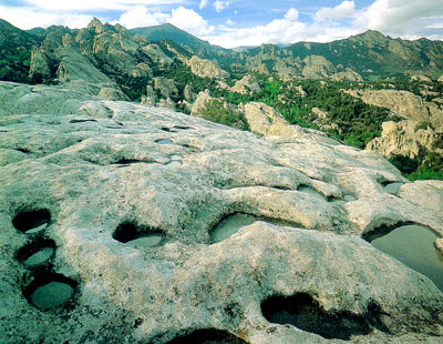
Jointing is well developed in some parts of the batholith and is an important structural control in establishing the basic forms in the City of Rocks. Spacing of the joints varies widely. There are three intersecting joint sets: a northwest trend, a northeast trend, and a horizontal trend. Jointing controls the arrangement of outcrops. Joints facilitate the weathering processes by providing a plumbing system for solutions to migrate into the outcrops to cause the alteration and disintegration of surface layers of granite. These large fracture channels for fluids make it possible for blocks to separate and form tall, isolated monoliths such as spires and turrets.
Rock Types
The Cassia Batholith contains rock ranging from granite to granodiorite. The inner core occupied by the City of Rocks tends to be granodiorite; whereas granite is more common for the outer area. A gneissic texture is characteristic of the outer zone.
The Almo Pluton
The granite in the City of Rocks is part of the Almo pluton. Armstrong (1976) has determined that this epizonal (shallow) pluton is 28.3 million years old, much younger than most of the granitic rock in Idaho. The shallow emplacement of the pluton is indicated by its lack of foliation at the margins and the discordant contacts it makes with the surrounding older quartzite.
Pegmatites
Scattered pegmatite dikes, which have the composition and texture of coarse-grained granite, may be observed throughout the Cassia Batholith. Pegmatites range from thin seams to lenticular bodies up to 50 feet across and several hundred feet long. One exceptionally large pegmatite crops out in the City of Rocks. This pegmatite may be one of the largest to be found in Idaho with exposed dimensions of 200 to 300 feet wide and 400 to 500 feet long. Large masses of orthoclase feldspar, quartz and muscovite are well exposed over two rounded knolls that make up the pegmatite. Some of the masses of quartz and feldspar are tens of feet in diameter. Masses of muscovite display radiating crystals. Smoky quartz and miarolitic cavities are common. Numerous small workings over this large pegmatite show evidence of past interest and activity.
Weathering
Although jointing controls the general form of outcrops in the City of Rocks, weathering is the agent responsible for creating the bizarre and fantastic shapes that characterize the area. On the surface of the outcrops the weathering occurs by granular disintegration. In other words one layer of crystals after another is successively removed from the surface, This leaves the newly exposed surface in a smooth rounded condition with no sharp or ragged edges or corners. The detrital material weathers from the granite and is carried by wind and water to low areas among the prominent forms. This process has already removed some of the layers of rock bearing 150-year-old signatures left by the pioneers.
Wildlife
Part of Idaho's Minidoka Bird Refuge, the City of Rocks is home to eagles, falcons, vultures, hawks, hummingbirds, jays, sparrows, doves, and the state bird, the mountain bluebird. Among the mammals that live within the park are elk, mule deer, mountain lions, coyotes, badgers, bobcats, porcupines, ground squirrels, and bats. Reptiles such as the sand lizard, watersnake, blowsnake, rubber boa, and the park's only poisonous snake, the rattlesnake (found only at lower elevations), also live within the City of Rocks. All plants and animals are protected by law and should not be disturbed.
Vegetation
The range of elevations within the compact area of the Reserve combines with other factors to create varied patterns of vegetation and wildlife habitat. At high elevations the forests are of lodgepole pine, limber pine, and Douglas fir. Middle elevation forests are of quaking aspen, mountain mahogany, and cottonwood. Sagebrush, pinyon pines, and juniper dominate lower elevations. The Reserve boasts Idaho's tallest pinyon pines, at more than 55 feet. The nuts of the trees provide important proteins and fats for wildlife. In addition to the trees, spring and summer displays of wildflowers can be spectacular. Over 450 plant species have been recorded at the City of Rocks.
Did you know there is another City of Rocks in Idaho? Click here for more information!