 |
Terms
& Phrases
 |
Click here to view a detailed map of the Great Rift system.
|
Terms
& Phrases
|
Click here to view a detailed map of the Great Rift system.
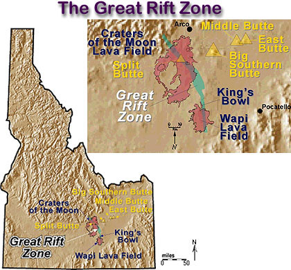
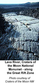
The Great Rift system consists of a series of north-northwest-trending fractures, which extend 50 miles from the northern margin of the eastern Snake River Plain, southward to the Snake River. In 1968, the Great Rift was designated as a national landmark.
The system has been divided into four separate sets of fractures. These four sets from north to south include: (1) the Great Rift set which trends N. 35' W. and cuts across the Craters of the Moon National Monument; (2) the Open Crack rift set which trends N. 30' W. and apparently has not experienced extrusive activity; (3) the King's Bowl rift set which trends N. 10' W; and (4) the Wapi rift set which is believed to trend north-south, but is covered by the Wapi flow. The total rift system is 62 miles long and may be the longest known rift zone in the conterminous United States.
Recent Volcanism of
the Eastern Snake
River Plain
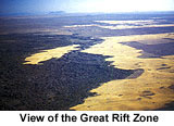
Very fresh basalt can be found at five different locations: the Cerro Grande and other flows near Big Southern Butte; Hells Half Acre lava field near Blackfoot; Wapi lava field; Craters of the Moon lava field; and King's Bowl lava field. The last three originate from the great rift system. The younger flows lack vegetation so that they clearly stand out on aerial photographs.
King's Bowl Rift Set
The King's Bowl Rift set includes a central fissure with sets of symmetrical tension cracks on both sides. It is about 6.5 miles long, 0.75 mile wide and trends N. 10' W. The main fissure is about 6 to 8 feet wide and is mostly filled with breccia and feeder dikes. In certain areas it is possible to descend into the rift several hundred feet. King's Bowl, which was created by one or more phreatic eruptions, is the most prominent feature on the rift. The ash blocks and rubble around the crater are evidence for an explosive eruption. Well-developed pipe-shaped vesicles are exposed in a massive flow on the east wall of King's Bowl. These vertically aligned vesicles indicate the path of gas escaping from the base of the flow. The direction of the flow is indicated by the bend in the vesicles. These vesicles average about one-half inch in diameter.
Crystal Ice Cave
Crystal Ice Cave consists of natural and manmade passages through the King's Bowl Rift set. In this cave one can observe dikes, breccia zones and soil horizons between flows. The cave is named for the ice formation that developed from the freezing of surface water that seeped into the fissure. The King's Bowl lava field represents the last activity in the area and has been dated at 2,130 years.
Inferno Chasm
Rift Zone
The Inferno Chasm Rift Zone consists of a number of volcanic features all aligned along a rift trending N. 4' W. These features from north to south include Wildhorse Corral, Cottrell's Blowout, Inferno Chasm, Grand View Crater and possibly Papadakis Perched Lava Pond. All of these features are summit vents for coalescing lava shields.
Wild Horse Corral
Wild Horse Corral is an irregular-shaped depression about 3,070 feet long and 1,850 feet wide. The long axis is subparallel to the rift set. A flat terrace, approximately 165 feet wide, encircles the canyon walls and the crater floor. Wild Horse Corral may have started as two eruptions and coalesced into a single large fissure vent.
Bear Trap lava tube is situated west of Wild Horse Corral. This tube trends west-northwest for a distance of 3 miles, The Bear Trap lava flow probably came from the Wild Horse Coral vent.
A lava lake may have filled Wild Horse Crater periodically. After the lake was drained, the vent collapsed creating the present crater. The lava lake again filled and partially drained leaving a 165-footwide terrace around the crater walls.
Cottrell's Blowout
Cottrell's Blowout was started from a fissure vent along the Inferno Chasm Rift set. It is 1,950 feet long and 52 5 feet wide with a maximum depth of 140 feet. This feature was built by a succession of thin, gas-charged flows. Cottrell's Blowout formed as a result of a collapse to form a crater. The collapse was caused by the withdrawal of magma down the vent.
Inferno Chasm
This feature is an irregular circular vent 575 feet in diameter and 70 feet deep. It has a meandering lava channel that extends about 4,700 feet to the west.
Grandview Crater
Grandview Crater is a shallow depression that served as a vent for a lava shield near the southern end of the Inferno Chasm Rift Zone.
Papadakis Perched
Lava Pond
Papadakis Perched Lava Pond is the remnant of a former lava lake on the west side of the Inferno Chasm Rift Zone. It is a fan-shaped, shallow depression, approximately 3,800 feet long and 2,600 feet wide. The lava lake was fed by a spatter cone 2,000 feet west of the rift zone.
Split Butte
Split Butte, situated about 6 miles southwest of King's Bowl, is believed to be a maar crater. The name refers to a split or gap in the upper tephra layers at the east side of the butte. Prevailing west winds have caused the tephra ring to be asymmetrical. The winds caused more pyroclastic debris to be piled on the east side. The split, which is located on the east side is believed to be caused by wind erosion.
The tephra ring had an explosive pyroclastic phase. When the first flow erupted, it passed through ground water. This caused glassy ash to form due to the cold water coming in contact with the hot lava. After the water saturated sediments were sealed, pyroclastic activity ceased and a lava lake formed. The lava lake partly overflowed and then crusted over. After withdrawal of liquid lava below the crust, the central portions of the crust collapsed.
King's Bowl
King's Bowl is a crater 280 feet long, 100 feet across and 100 feet deep. It stands directly over the main fracture of the Great Rift. Kings Bowl crater is the source of the 2,222 year old King's Bowl lava flow. Immediately west of the crater is an ejecta field where large blocks of rubble blown from the vent are strewn all over the ground. The size of blocks decreases with distance from the crater. A field of squeeze-up structures nearby was caused by lava being squeezed up through fractures. Some are hollow indicating that lava was drained out shortly after formation. The ash and ejecta fields were caused by ground water coming in contact with lava upwelling from the vent.
Wapi Lava Field
The Wapi Lava Field is located at the southern end of the Great Rift System. The Wapi lava field is a broad shield volcano covering approximately 260 square miles. The cone consists of many aa and pahoehoe flows which are replete with lava tubes and channels. The Wapi lava field formed about 2,270 years ago, almost simultaneously with the King's Bowl lava field.
Sand Butte
Sand Butte is located 23 miles southwest of Craters of the Moon National Monument. Sand Butte first formed as a tuff cone and was later filled by a lava lake. It is situated on a 3-mile-long, north-southtrending fissure. The fissure ranges from 200 to 410 feet wide. Sand Butte, like Split Butte, was formed by the phreatomagmatic interaction of ground water and basaltic magma. Pyroclastic flow was the primary method of deposition. The basalt was erupted after the phreatic phase ended. This is demonstrated by tongues of spatter which overlie the tephra deposits. The final event was the partial filling of the crater by a lava lake. Finally the lava lake subsided to form a shallow crater.
Big Southern Butte
Big
Southern Butte, Middle Butte and East Butte are three large buttes which
can be seen rising above the eastern Snake River Plain while driving between
Arco and Idaho Falls on Highway 20. All three buttes are situated east of
the highway. Middle Butte appears to be an uplifted block of basalt. Although
no rhyolite is exposed at the surface, the butte was probably formed by
a silicic intrusion forcing the basalt upwards into the form of a butte.
Big Southern Butte and East Butte are rhyolite domes. East Butte has been
dated at 600,000 years, whereas Big Southern Butte has been dated at 300,000
years.
Big Southern Butte, because of its prominence and size, was an important
landmark for the early settlers. It rises 2,500 feet above the plain and
is approximately 2,500 feet across the base. Access to the top of the butte
is available by a Bureau of Land Management service road. The butte was
formed by two coalesced cumulo domes of rhyolite that uplifted a 350 foot
section of basalt. The basalt section now covers most of the northern side
of the butte. The dome on the southeastern side was developed by internal
expansion (endogenous growth). Rupture of the crust at the surface caused
breccia to form. Obsidian, pumice and flow-banded rhyolite are important
components.
Once part of a continuous flow on the surface of the Snake River Plain, the large basalt block was pushed up and tilted by intrusion of the rhyolite. The basalt block now dips about 45 degrees to the northeast. This block consists of 15 to 20 individual flow units.
Lava Tubes
Lava tubes are important for the emplacement of lava on the Snake River Plain. Lava tubes are the subsurface passage ways that transport lava from a vent to the site of emplacement. They form only in the fluid pahoehoe flows. Tubes originate from open flow channels that become roofed over with crusted or congealed lava. However a tube may also form in a massive flow. Lava tubes exist as a single tunnel or as complex networks of horizontally-anastomosing tubes and may occupy up to five levels. Most tubes tend to be 6 to 13 feet across. Access to some tubes may be gained through collapsed sections. Features in tubes include glazed lava, lava stalactites and ice.
Great Rift Unrelated
to Basin and Range
Although many of the volcanic rift zones in the central and eastern Snake River Plain may be extensions of northwest-trending, range-front faults, the Great Rift does not appear to be a continuation of such a fault.
Click here to view the location of other rift systems in the conterminous United States.
|
Supplemental Material The field guides below are a part of the Guidebook to the Geology of Eastern Idaho :
Also Visit
|
This module was created by Digital Atlas staff members.