Geologic Units |
|
| Quaternary alluvial deposits | |
| Quaternary surficial cover, fluveolian cover on Snake River Plain, alluvial fans (Snake River Group) | |
| Pleistocene silicic volcanic rocks (Yellowstone Group) | |
| Pleistocene basalt lava | |
| Pliocene and Upper Miocene felsic volcanic rocks, rhyolite flows, tuffs, ignimbrites (includes Moonstone rhyolite) | |
| Cretaceous sedimentary rocks | |
| Jurassic sedimentary rocks. | |
| Triassic sedimentary rocks | |
| Permian and Pennsylvanian sedimentary rocks | |
| Mississippian sedimentary rocks | |
| Devonian sedimentary rocks |
| Map Key | |
| Geologic units with unit designation. | |
| Normal Fault: certain; dashed where approximately located; dotted where concealed. | |
| Thrust Fault: certain; dashed where approximately located; dotted where concealed. | |
| Detachment Fault: certain; dashed where approximately located; dotted where concealed. | |
| Interstate Route. | |
| U.S. Route. | |
| State Route. | |
| Location of Rockwalk rock from the county. | |
| Cities. | |
| Feature location. |
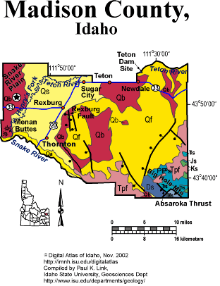
Madison County
Madison County contains the northwest end of the Idaho-Wyoming thrust belt in the Big Hole Mountains. On the south is the Snake River half-graben, bounded by the active Rexburg fault. On the north and west are the wide, irrigated Teton bench and Upper Valley of the Snake River Plain.
The Absaroka thrust places Devonian over Mesozoic strata in the Big Hole Mountains, which extend southwestward into the complex mountains of the Idaho-Wyoming thrust belt. The Big Hole range is bounded on the west by a normal fault, the northwest extension of the Grand Valley fault, which controls the location of the Snake River and its half-graben valley west of Heise. North of Heise, in the cliffs below Kelly Canyon ski area are spectacular exposures of rhyolite volcanic rocks of the Heise caldera, erupted between 4 and 6 million years ago.
Quaternary basaltic volcanism has produced the landscape of the western part of Madison county, with still active basaltic lava fields present. Menan Buttes are a phreatomagmatic eruptive tuff cones that formed where basalt magma interacted with Snake River groundwater, producing explosive steam eruptions and the low, wide eruptive cones composed of both basalt tephra and Snake River gravel cobbles and pebbles.
The northeastern part of the county lies on benches above the Teton River. The benches slope upward toward the Yellowstone plateau, and are underlain by Quaternary rhyolite covered by windblown loess. The Teton Dam, which broke with a catastrophic flood in 1976, was located in the Teton River canyon, anchored in Pleistocene rhyolite ignimbrite of the 2 Ma Huckleberry Ridge tuff.
See text on Snake River Plain-Yellowstone Hot Spot in Rocks, Rails and Trails, Topographic Development of Idaho maps, and Embree et al. field trip in Guidebook to the Geology of Eastern Idaho.
P.K. Link, 10/02
Additional Reading
Rocks Rails and Trails: pages
Introduction to the Geology of South & East Idaho
Introduction to Geologic Diagrams
Geologic cross sections
Relations between Geology, Topography and Drainage Systems in Idaho
Drainage and mountain range map for eastern Idaho
Table of Geologic Events in Southern Idaho
The Snake River Plain-Yellowstone Hot Spot and its Effect on Drainage Patterns
Challis Volcanic Group & Intrusive Rocks
References on Idaho Geology
Section 3, History of Eastern Idaho
Section 3, Chapter 8 -"Famous Potatoes" Agriculture & Irrigation
The Teton Dam Disaster, June 5, 1976
Click here to see a correlation of geologic units, and the associated time scale.
Click here for a printable version of this map.
|
Click on the button below to search the IdahoGeologic
Survey's index of Geologic Maps
|
 |