Geologic Units |
|
| Tertiary sedimentary rocks, undifferentiated | |
| Miocene basalt (Columbia River Basalt Group) | |
| Oligocene volcanics (Potlatch volcanics and Salmon Falls Creek volcanics) | |
| Eocene Challis Volcanic Group, volcanics and volcaniclastics | |
| Cretaceous syenitic rocks | |
| Cretaceous granite and granodiorite of the 2-mica suite (Idaho batholith) | |
| Mesoproterozoic augen gneiss and porphyritic granite | |
| Schist of the Wallace Formation and lower Missoula Group | |
| Quartzite and calc-silicate gneiss of the Wallace Formation | |
| Quartzite and schist of the Ravalli group | |
| Upper Missoula Group. Upper part Swauger Quartzite (Mount Shields, Bonner, and Libby Fms.) | |
| Lower Missoula Group. Lower part-- Gunsight Formation (Snowslip and Shepard) | |
| Metamorphic rocks, Elk City metamorphic sequence and related rocks, Syringa metamorphic sequence, and Priest River metamorphic complex |
| Map Key | |
| Geologic units with unit designation. | |
| Normal Fault: certain; dashed where approximately located; dotted where concealed. | |
| Thrust Fault: certain; dashed where approximately located; dotted where concealed. | |
| Detachment Fault: certain; dashed where approximately located; dotted where concealed. | |
| Interstate Route. | |
| U.S. Route. | |
| State Route. | |
| Location of Rockwalk rock from the county. | |
| Cities. | |
| Feature location. |
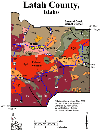
Latah County
The rolling Palouse of western Latah County is underlain by loess hills deposited above Miocene Columbia River basalt that flowed eastward from vents in Washington. Miocene and younger sediments were deposited upstream of the ends of these basalt flows and underlie much of the farming country between Moscow and Bovill.
The unique Oligocene Potlach volcanics are found in the northwestern part of the quadrangle. The Potato Hill volcanics are found west of Bovill.
The eastern part of the county is underlain by Mesoproterozoic Belt Supergroup, with the metamorphosed garnet-bearing Wallace Formation exposed in the northeastern part of the county, south of Fernwood and the Emerald Creek garnet district.
The central part of the county is underlain by Cretaceous granodiorite, one of the northern parts of the Idaho batholith, that extends westward into eastern Washington.
Written by P.K. Link, 9/02
Additional Reading
Rocks Rails and Trails: page
References on Idaho Geology
Click here to see a correlation of geologic units, and the associated time scale.
Click here for a printable version of this map.
|
Click on the button below to search the IdahoGeologic
Survey's index of Geologic Maps
|
 |