Geologic Units |
|
| Quaternary alluvial deposits | |
| Missoula Flood deposits | |
| Tertiary sedimentary rocks, undifferentiated | |
| Miocene basalt (Columbia River Basalt Group) | |
| Eocene granite, pink granite, syenite, rhyolite dikes, and rhyolitic shallow intrusive | |
| Eocene granodiorite, granite, diorite, and shallow dacitic intrusive | |
| Cretaceous granite and granodiorite of the hornblende-biotite suite (includes megacrystic granodiorite and granite) | |
| Cretaceous orthogneiss, and foliated granodiorite and granite (includes mylonitic plutonic rocks in western Idaho suture zone) | |
| Cambrian sedimentary rocks | |
| Mesoproterozoic augen gneiss and porphyritic granite | |
| Upper Missoula Group. Upper part Swauger Quartzite (Mount Shields, Bonner, and Libby Fms.) | |
| Lower Missoula Group. Lower part-- Gunsight Formation (Snowslip and Shepard) | |
| Piegan Group or Middle Belt carbonate, Apple Creek Formation (includes Cobalt and Yellowjacket Formations, and Yaq argillaceous quartzite unit of Ekren) | |
| Ravalli Group, includes Hoodoo Quartzite, Big Creek Formation, Yellowjacket Formation, lower part of Lemhi Group | |
| Prichard Formation (Lower Belt), includes Yqcp quartzite and carbonate rocks in Prichard | |
| Metamorphic rocks, Elk City metamorphic sequence and related rocks, Syringa metamorphic sequence, and Priest River metamorphic complex |
| Map Key | |
| Geologic units with unit designation. | |
| Normal Fault: certain; dashed where approximately located; dotted where concealed. | |
| Thrust Fault: certain; dashed where approximately located; dotted where concealed. | |
| Detachment Fault: certain; dashed where approximately located; dotted where concealed. | |
| Interstate Route. | |
| U.S. Route. | |
| State Route. | |
| Location of Rockwalk rock from the county. | |
| Cities. | |
| Feature location. |
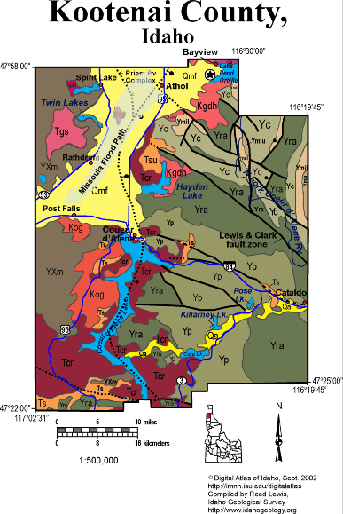
Kootenai County
The bulk of Kootenai County south and east of Coeur d'Alene is underlain by Mesoproterozoic Belt Supergroup rocks continuing west from their extensively mineralized area along the Lewis and Clark fault zone, in the Silver Valley in Shoshone County.
The western part of the county, west of Coeur d'Alene Lake and the Rathdrum Prairie belongs to the lower plate of the Priest River core complex. The normal fault bounding the uplifted metamorphic rocks of the core complex dips eastward and follows the north-trending basin of Lake Coeur d'Alene.
The south fork of the Coeur d'Alene River contains mining wastes from the Silver Valley. The area near Rose and Killarney Lakes as well as at Cataldo, contains a layer of zinc and lead-rich gravel or tailings, in the shallow subsurface. When the lake level changes these mine wastes are disturbed and metals may be released into solution. This is an ongoing scientific, political, and economic challenge.
The Lake Missoula Floods charged southwestward down the Rathdrum Prairie toward Post Falls, and into the Spokane River in eastern Washington.
Miocene Columbia River basalts cover the rolling Palouse country of the southwestern part of the County, north of the Coeur d'Alene Tribal Casino.
Cretaceous intrusive rocks are found in the core of the Priest River uplift south of Coeur d'Alene, and northeast of Hayden Lake. Eocene granitic rocks intrude the core complex west of Spirit Lake.
Written by P.K. Link, 9/02
Additional Reading
Rocks Rails and Trails: page
References on Idaho Geology
Click here to see a correlation of geologic units, and the associated time scale.
Click here for a printable version of this map.
|
Click on the button below to search the IdahoGeologic
Survey's index of Geologic Maps
|
 |