Geologic Units |
|
| Quaternary alluvial deposits | |
| Quaternary surficial cover, fluveolian cover on Snake River Plain, alluvial fans (Snake River Group) | |
| Pleistocene basalt lava | |
| Pleistocene and Pliocene basalt lava and associated tuff |
| Map Key | |
| Geologic units with unit designation. | |
| Normal Fault: certain; dashed where approximately located; dotted where concealed. | |
| Thrust Fault: certain; dashed where approximately located; dotted where concealed. | |
| Detachment Fault: certain; dashed where approximately located; dotted where concealed. | |
| Interstate Route. | |
| U.S. Route. | |
| State Route. | |
| Location of Rockwalk rock from the county. | |
| Cities. | |
| Feature location. |
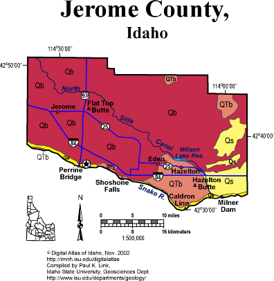
Jerome County
Jerome County is on the north side of the Snake River, totally within the Snake River Plain. Thus all the rocks are Miocene or younger, and mainly basalt lava flows. A few areas of Quaternary sediment make good irrigated farming.
Near Eden and Hazelton are dry cascades and waterfalls formed during the Lake Bonneville Flood about 15,000 years ago. There was too much water for the Snake River Canyon, and the excess overflowed in a now-dry flood channel that isolated an island south of Hazelton. The area east of Eden has some spectacular potholes.
P.K. Link, 9/02
Additional Reading
Rocks Rails and Trails: pages
The Snake River Plain-Yellowstone Hot Spot and its Effect on Drainage Patterns
Challis Volcanic Group & Intrusive Rocks
Lake Bonneville and its Flood
Disposal of Wastes at the Idaho National Engineering & Environmental Laboratory
References on Idaho Geology
Section 3, History of Eastern Idaho
Section 3, Chapter 8 -"Famous Potatoes" Agriculture & Irrigation
Section 7, Chapter 23 - Twin Falls Area & the Magic Valley
Click here to see a correlation of geologic units, and the associated time scale.
Click here for a printable version of ths map.
|
Click on the button below to search the IdahoGeologic
Survey's index of Geologic Maps
|
 |