Geologic Units |
|
| Quaternary alluvial deposits | |
| Quaternary surficial cover, fluveolian cover on Snake River Plain, alluvial fans (Snake River Group) | |
| Quaternary windblown deposits, dunes, loess | |
| Pleistocene silicic volcanic rocks (Yellowstone Group) | |
| Pleistocene basalt lava | |
| Pleistocene and Pliocene basalt lava and associated tuff | |
| Pliocene and Upper Miocene felsic volcanic rocks, rhyolite flows, tuffs, ignimbrites (includes Moonstone rhyolite) |
| Map Key | |
| Geologic units with unit designation. | |
| Normal Fault: certain; dashed where approximately located; dotted where concealed. | |
| Thrust Fault: certain; dashed where approximately located; dotted where concealed. | |
| Detachment Fault: certain; dashed where approximately located; dotted where concealed. | |
| Interstate Route. | |
| U.S. Route. | |
| State Route. | |
| Location of Rockwalk rock from the county. | |
| Cities. | |
| Feature location. |
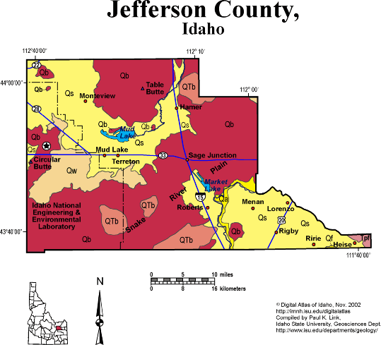
Jefferson County
Jefferson County is entirely on the Snake River Plain, mainly north and west of the Snake River where it takes its horseshoe bend from flowing northwest to flowing south. The bend, likely controlled by the topographic high of the Menan Buttes in adjacent Madison County, allows Jefferson County to have large areas of rich irrigated agriculture in the south and east near Rigby and Market Lake.
The northern and western parts of Jefferson County are Quaternary basalt lava, with the sedimentary basin of Mud Lake in the northwest corner. Around Mud Lake is another area of irrigated farming, with soils formed from lake beds of Lake Terreton, which occupied this area in much of Quaternary time. The northeast corner of the INEEL occupies the western edge of Jefferson County.
See discussion of geology of the Yellowstone-Snake River Plain volcanic system in Rocks, Rails and Trails, Topographic Development of Idaho maps, and Hughes et al. and Embree et al. papers in Geology of Eastern Idaho.
P.K. Link, 10/02
Additional Reading
Rocks Rails and Trails: pages
Introduction to the Geology of South & East Idaho
Introduction to Geologic Diagrams
Geologic cross sections
Relations between Geology, Topography and Drainage Systems in Idaho
Drainage and mountain range map for eastern Idaho
Table of Geologic Events in Southern Idaho
The Snake River Plain-Yellowstone Hot Spot and its Effect on Drainage Patterns
Challis Volcanic Group & Intrusive Rocks
References on Idaho Geology
Section 3, History of Eastern Idaho
Section 3, Chapter 8 -"Famous Potatoes" Agriculture & Irrigation
The Teton Dam Disaster, June 5, 1976
Click here to see a correlation of geologic units, and the associated time scale.
Click here for a printable version of this map.
|
Click on the button below to search the IdahoGeologic
Survey's index of Geologic Maps
|
 |