|
|
Click on the map for a larger version
|
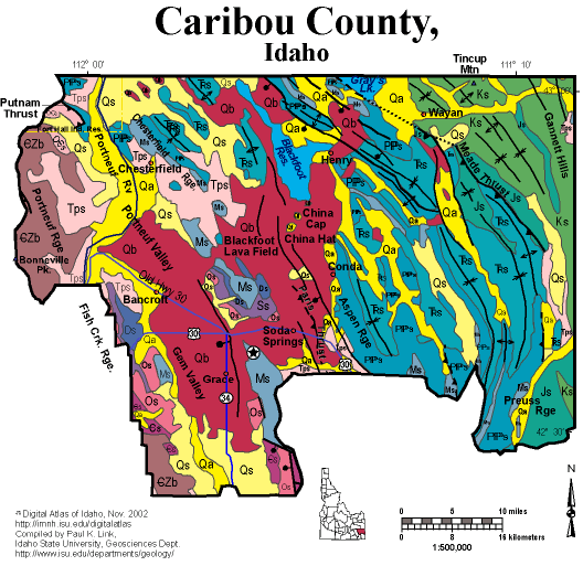
Geologic Units |
|
| Quaternary alluvial deposits | |
| Quaternary surficial cover, fluveolian cover on Snake River Plain, alluvial fans (Snake River Group) | |
| Pleistocene basalt lava | |
| Pliocene and Upper Miocene stream and lake deposits (Salt Lake Formation, Starlight Formation, Idaho Group) | |
| Cretaceous sedimentary rocks | |
| Jurassic sedimentary rocks. | |
| Triassic sedimentary rocks | |
| Permian and Pennsylvanian sedimentary rocks | |
| Mississippian sedimentary rocks | |
| Silurian sedimentary rocks | |
| Devonian sedimentary rocks | |
| Ordovician sedimentary rocks | |
| Ordovician and Cambrian sedimentary rocks | |
| Cambrian sedimentary rocks | |
| Cambrian to Neoproterozoic Brigham Group |
| Map Key | |
| Geologic units with unit designation. | |
| Normal Fault: certain; dashed where approximately located; dotted where concealed. | |
| Thrust Fault: certain; dashed where approximately located; dotted where concealed. | |
| Detachment Fault: certain; dashed where approximately located; dotted where concealed. | |
| Interstate Route. | |
| U.S. Route. | |
| State Route. | |
| Location of Rockwalk rock from the county. | |
| Cities. | |
| Feature location. |
Caribou County
Caribou County has the forested mountains of the Idaho-Wyoming thrust belt on its eastern side, and the wide Bear Lake and Gem valleys on its west, part of the Basin and Range province. Pleistocene volcanic rocks, mainly basalts, fill the Blackfoot Lava field and much of Gem Valley to the west. China Hat and China Cap are Pleistocene rhyolite domes. Phosphate mining still controls the economy of Caribou County, with active mines operated by Simplot, FMC, Monsanto, and Agrium between Soda Springs and Afton, Wyoming.
For more information see geology text from Rocks, Rails and Trails. Also see the Fortsch and Link field trip from "Geologic Guidebook to Eastern Idaho".
P.K. Link, 10/02
Additional Reading
Rocks Rails and Trails: pages
Introduction to the Geology of South & East Idaho
Introduction to Geologic Diagrams
Geologic cross sections
Relations between Geology, Topography and Drainage Systems in Idaho
Drainage and mountain range map for eastern Idaho
Table of Geologic Events in Southern Idaho
Drainage Systems, Rails and Trails
Geologic Provinces along the Oregon Trail
Rocks of the Eastern Idaho Mountains
Southeast Idaho Phosphate Mining
The Thrust Belt of Southeastern Idaho
Views of Thrust Faults
References on Idaho Geology
Section 3, History of Eastern Idaho
Section 3, Chapter 8 -"Famous Potatoes" Agriculture & Irrigation
Montpelier
Geology of the Soda Springs Area
Section 4, Chapter 11 -Caribou Mountain Area
Section 4, Chapter 12 -Gem Valley & Chesterfield
Click here to see a correlation of geologic units, and the associated time scale.
Click here for a printable version of this map.
|
Click on the button below to search the IdahoGeologic
Survey's index of Geologic Maps
|
 |