Geologic Units |
|
| Quaternary alluvial deposits | |
| Quaternary moraine and glaciofluvial outwash | |
| Quaternary lake floor and playa deposits (Snake River Group), and glacial lake deposits in northern Idaho. | |
| Cretaceous granite and granodiorite of the 2-mica suite (Idaho batholith) | |
| Cretaceous granite and granodiorite of the hornblende-biotite suite (includes megacrystic granodiorite and granite) | |
| Jurassic and Cretaceous granitic intrusive rocks, Kootenay arc. | |
| Cretaceous syenitic rocks | |
| Neoproterozoic Windermere Supergroup (metasedimentary and metavolcanic rocks in Big Creek area and northern Idaho) | |
| Neoproterozoic Deer Trail Group | |
| Lower Missoula Group. Lower part-- Gunsight Formation (Snowslip and Shepard) | |
| Piegan Group or Middle Belt carbonate, Apple Creek Formation (includes Cobalt and Yellowjacket Formations, and Yaq argillaceous quartzite unit of Ekren) | |
| Ravalli Group, includes Hoodoo Quartzite, Big Creek Formation, Yellowjacket Formation, lower part of Lemhi Group | |
| Prichard Formation (Lower Belt), includes Yqcp quartzite and carbonate rocks in Prichard |
| Map Key | |
| Geologic units with unit designation. | |
| Normal Fault: certain; dashed where approximately located; dotted where concealed. | |
| Thrust Fault: certain; dashed where approximately located; dotted where concealed. | |
| Detachment Fault: certain; dashed where approximately located; dotted where concealed. | |
| Interstate Route. | |
| U.S. Route. | |
| State Route. | |
| Location of Rockwalk rock from the county. | |
| Cities. | |
| Feature location. |
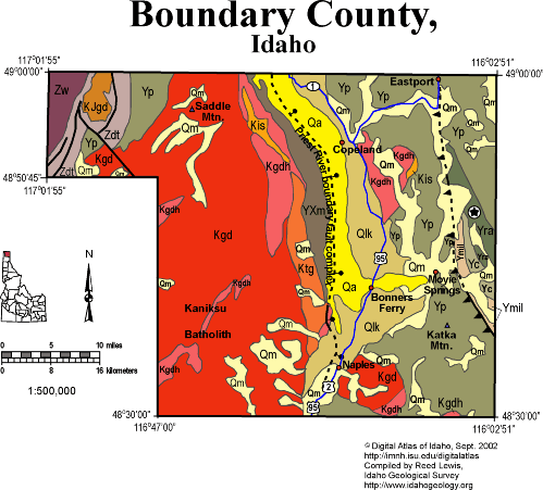
Boundary County
Boundary County lies at the north end of the Idaho panhandle, and borders Canada. The western portion of the county is part of the Priest River uplift, exposing Cretaceous granitic rocks of the Kaniksu batholith, that intrude Mesoproterozoic Belt Supergroup, and overlying Neoproterozoic Deer Trail and Windermere groups and Cambrian rocks. A small Jurassic or Cretaceous granodiorite intrudes the Deer Trail Group in the northwestern part of the county. This intrusive is associated with accretion of rocks in British Columbia known as the Kootenay arc, a possible island-arc terrane.
The eastern portion of the county, east of the east-dipping normal fault that bounds the Priest River core complex uplift, contains Belt Supergroup with small Cretaceous intrusions. A west-dipping thrust fault runs northwest-southeast, through Eastport, and formed during Cretaceous crustal shortening.
Bonners Ferry, Eastport, and most of the habitable ground is found on the flat valley of the Kootenai and Moyie rivers, which flow north into Canada before joining the Columbia, whose course bends south and returns to the USA in eastern Washington. A glacial lake, dammed by piedmont ice to the north, occupied this long-north-trending valley, and so fine-grained lake beds underlie much of the Kootenai Valley.
P.K. Link, 9/02
Additional Reading
Rocks Rails and Trails: page
References on Idaho Geology
Click here to see a correlation of geologic units, and the associated time scale.
Click here for a printable version of this map.
|
Click on the button below to search the IdahoGeologic
Survey's index of Geologic Maps
|
 |