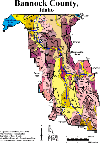
Geologic Units |
|
| Quaternary alluvial deposits | |
| Quaternary windblown deposits, dunes, loess | |
| Quaternary surficial cover, fluveolian cover on Snake River Plain, alluvial fans (Snake River Group) | |
| Bonneville Flood gravels | |
| Lake Bonneville deposits | |
| Pleistocene basalt lava | |
| Pliocene and Upper Miocene stream and lake deposits (Salt Lake Formation, Starlight Formation, Idaho Group) | |
| Triassic sedimentary rocks | |
| Oligocene volcanics | |
| Permian sedimentary rocks | |
| Permian and Pennsylvanian sedimentary rocks | |
| Devonian sedimentary rocks | |
| Mississippian sedimentary rocks | |
| Silurian sedimentary rocks | |
| Silurian and Ordovician sedimentary rocks | |
| Ordovician sedimentary rocks | |
| Ordovician and Cambrian sedimentary rocks | |
| Cambrian sedimentary rocks | |
| Lower Paleozoic sedimentary rocks (includes roof pendants near Stanley) | |
| Cambrian to Neoproterozoic Brigham Group | |
| Neoproterozoic Pocatello Formation |
| Map Key | |
| Geologic units with unit designation. | |
| Normal Fault: certain; dashed where approximately located; dotted where concealed. | |
| Thrust Fault: certain; dashed where approximately located; dotted where concealed. | |
| Detachment Fault: certain; dashed where approximately located; dotted where concealed. | |
| Interstate Route. | |
| U.S. Route. | |
| State Route. | |
| Location of Rockwalk rock from the county. | |
| Cities. | |
| Feature location. |
Bannock County
Bannock County straddles the boundary between the Basin and Range, Idaho-Wyoming thrust belt, and Snake River Plain. There are extensive discussions of the geology of Bannock County, including Marsh Valley and Lava Hot Springs in Rocks, Rails and Trails.
Bannock County contains folded and thrust-faulted Neoproterozoic and Paleozoic strata in the Bannock and Portneuf Ranges. The intervening Marsh Valley is a Miocene to recent feature, bounded by a normal fault on the east side.
The Basalt of Portneuf Valley flowed down the Portneuf River path about 600,000 years ago, and now forms inverted topography in the middle of Marsh Valley.
The Lake Bonneville flood broke out at Red Rock Pass in southern Bannock County about 14,500 years ago and flowed north through Marsh Valley and Portneuf Narrows before is spread out in the Pocatello area as it emptied onto the Snake River Plain. Flood boulders are distinctive landscape elements in the Pocatello and Chubbuck areas.
See Geology and regional sections of Rocks, Rails and Trails.
P.K. Link, 10/02
Additional Reading
Rocks Rails and Trails: pages
Introduction to the Geology of South
& East Idaho ,
Introduction to Geologic Diagrams,
Geologic cross sections,
Relations between Geology, Topography
and Drainage Systems in Idaho,
Drainage and mountain range map for
eastern Idaho.,
Table of Geologic Events in Southern
Idaho,
Drainage Systems, Rails and Trails,
Geologic Provinces along the Oregon
Trail,
Rocks of the Eastern Idaho Mountains,
Southeast Idaho Phosphate Mining,
The Thrust Belt of Southeastern
Idaho,
Views of Thrust Faults,
Basin and Range Faulting,
Challis Volcanic Group & Intrusive
Rocks,
Lake Bonneville and its Flood,
The Lake Bonneville Flood in the
Pocatello Area,
Disposal of Wastes at the Idaho
National Engineering & Environmental Laboratory,
References on Idaho Geology,
Section 3, History of Eastern Idaho,
Section 3, Chapter 8 -"Famous
Potatoes" Agriculture & Irrigation
Section 4, Chapter 12 -Gem
Valley & Chesterfield ,
Lava Hot Springs and the Portneuf
River,
Section 4, Chapter 14 -Cache
Valley ,
Bear River Landslide Complex,
Section 4, Chapter 16 -Marsh
Valley ,
Section 4, Chapter 17 -Inkom
& the Portneuf Narrows ,
Pocatello: The Gate City ,
Pocatello: The Gate City ,
Section 6, Chapter 21 - American
Falls Area
Geologic Guidebook to Southeast Idaho: The Putnam Thrust plate
Click here to see a correlation of geologic units, and the associated time scale.
Click here for a printable version of this map.
Composite stratagraphic colum for bannock range.
|
Click on the button below to search the IdahoGeologic
Survey's index of Geologic Maps
|
 |