Stability &
Cloud Development
Cloud development is linked
closely with the concept of stability, i.e., the tendency of air to rise.
Although several factors determine whether or not clouds will form, the stability
of the atmosphere is far and away the single greatest indicator of cloud formation.
Air tends to cool and condense
as it rises, and to become warm and dry as it sinks. A Parcel of Air is
an imaginary mass of air that doesn't exchange properties with surrounding air
masses. In reality air masses do exchange properties, but this often occurs
very slowly, especially if the air masses are large. An adiabatic process
is one where no heat is exchanged between an air parcel and the surrounding
air. When we talk about an adiabatic process in the current context we are talking
about a rising (or sinking) parcel of air that is not exchanging any heat with
its surroundings. When air rises it cools at a relatively constant rate. If
the air is unsaturated, this rate, called the dry adiabatic rate, is
10°C per 1000m (5.5°F per 1000ft), i.e., a parcel of unsaturated
air cools by 100C every 1000 meters if it doesn't exchange heat with its surroundings.
As air rises and cools
its relative humidity increases. At some point the dew point equals the air
temperature and the air becomes saturated. Further lifting results in condensation
and cloud formation with an accompanying release of latent heat into the rising
parcel of air (remember that condensation is a warming process). Because the
heat liberated by condensation partially offsets the cooling due to expansion,
the parcel now cools at a lesser rate as it rises. This rate is known as the
moist adiabatic rate. The moist adiabatic rate applies to saturated air.
On average, the moist adiabatic
rate is less than the dry adiabatic rate. The moist adiabatic rate is not constant
but varies with temperature and moisture content. For cool air the moist adiabatic
rate ~ dry adiabatic rate. For warmer air the moist adiabatic rate is less than
the dry adiabatic rate. An average value of 6°C per 1000m (3.3°F per
1000ft) is commonly used.
To determine the stability
of an air parcel, one compares its temperature to the temperature of the surrounding
air mass. If the air parcel's temperature is less than the temperature of the
surrounding air mass, it is denser than the surrounding air and therefore has
a tendency to sink. Air that has a tendency to sink is known as a stable
air. If the air parcel's temperature is greater than the temperature of
the surrounding air mass, the air parcel is less dense and tends to rise. Rising
air, as we have already learned, is known as unstable.
For stable air, the environmental
lapse rate is 4°C per 1000m (2°F per 1000ft). When the environmental
lapse rate is less than the moist adiabatic rate an air parcel cools more quickly
than the surrounding air mass. This is known as absolute stability. ln
this case the air parcel strongly resists lifting. If the parcel is forced to
lift by mechanical means (such as orographic uplift or uplift along a frontal
boundary), it will spread out horizontally. Any clouds that form as a result
will be thin and horizontal such as cirrostratus, altostratus, nimbostratus,
and stratus clouds. All of these cloud types are associated with stable air.
Since the moist adiabatic
rate must be less than the environmental lapse rate for stable conditions to
exist, a moderate to small environmental lapse rate enhances stability in the
atmosphere. Warm air aloft (caused by warm advection) and cool air at the surface
(caused by nighttime radiational cooling, cold advection, or a cold surface)
result in a moderate to small environmental lapse rate.
Fog and haze form in stable
atmospheric conditions because of the large scale sinking of air. This can form
an inversion condition, known as a subsidence inversion.Subsidence inversions
are often associated with large high-pressure systems. Inversions are absolutely
stable because the air beneath the inversion is physically impeded from
moving upward. This traps large numbers of particulates close to the ground
that serve as fog-forming condensation nuclei.
Neutral Stability is
an atmospheric condition that occurs when the environmental lapse rate is
equal to the dry adiabatic rate.
Absolute instability
occurs when dry adiabatic rate is less than the environmental lapse rate.
In this situation, an air parcel will be warmer and less dense than the surrounding
air and will rise due to buoyant forces. Clouds with extensive vertical development
are indicative of absolute instability.
Conditional instability
is a state of instability that depends upon whether or not the rising air
is saturated.
Conditional stability
occurs when the environmental lapse rate is between the moist and dry adiabatic
rates. The atmosphere is normally in a conditionally unstable state.
Many factors lead to instability.
One is a steep environmental lapse rate resulting from cool air aloft (brought
on by cold advection, the environmental lapse rate or both) coupled with warm
air at the surface (caused by daytime solar heating, warm advection, or a warm
surface).
Mixing is another factor
that affects instability. Mixing increases warming below and cooling higher
up in the atmosphere.
Another factor that enhances
instability is lifting. When a layer of air is forced to rise it tends to become
more unstable because the top layer cools more rapidly than the bottom. This
steepens the environmental lapse rate. This effect is enhanced even more when
the lower layer of the lifted parcel is moist and the upper layer is dry. In
this case, less lifting is require to steepen the environmental lapse rate.
This is referred to as convective instability and is associated with
severe storms.
Cloud
Development:
The lifting mechanisms
associated with cloud development are:
* Surface heating and free convection
* Topography
* Convergence of surface air
* Uplift along fronts
* Convection (thermal development)
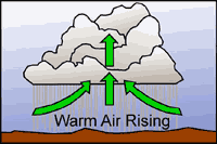
As the surface of the earth
heats up due to incoming solar radiation, warm bubbles of air (thermals) develop
and begin to rise. When these thermals reach a height known as the condensation
level, cumulus clouds begin to form. Cooler air surrounding the clouds sinks
to replace the warm air rising from the surface. The subsidence outside of the
cumulus clouds suppresses cloud formation in the area surrounding the clouds.
This is why one normally sees lots of blue sky surrounding fair-weather cumulus
clouds. Eventually, a growing cumulus cloud cuts off the ground from the sun's
rays, reducing surface heating and convection. The cloud begins to dissipate
and the process may start again. Fair weather cumulus clouds are often characterized
by level bases (at the condensation level), moderate vertical development, and
lots of blue sky in between.
 Convective
cloud formation is an adiabatic process, i.e., there is little mixing between
the air parcel and the surrounding air mass. A single thermal is all that is
necessary to produce a cumulus cloud. Cloud formation occurs when the relative
humidity within the parcel of rising air reaches 100%. After this point, the
parcel remains saturated as it rises.
Convective
cloud formation is an adiabatic process, i.e., there is little mixing between
the air parcel and the surrounding air mass. A single thermal is all that is
necessary to produce a cumulus cloud. Cloud formation occurs when the relative
humidity within the parcel of rising air reaches 100%. After this point, the
parcel remains saturated as it rises.
Suppose that the temperature
of a rising air parcel is 350C and the dew point 270C. At first the parcel is
buoyant and rises freely. The rising air in the parcel expands and cools at
the dry adiabatic rate. The dew point also drops but not as rapidly as the air
temperature due to the decrease in air pressure. As the unsaturated rising air
cools, the air temperature and dew point approach each other increasing
the relative humidity. At some height saturation occurs followed by condensation
and the formation of clouds. Above this level the air cools at the moist adiabatic
rate, condensation continues, and the dew point drops with height even more
rapidly than before. The temperature and dew point decrease at the moist adiabatic
rate.
The rising air parcel remains
warmer than the surrounding air mass and continues to rise. Eventually the air
parcel has a temperature equal to the air mass temperature and spontaneous lifting
ceases. Stability above the condensation level plays a major role in determining
the height of cumulus clouds. The stratosphere is quite stable. Seldom
do clouds penetrate the tropopause into the stratosphere. Vertical development
of a cumulus cloud also depends upon entrainment. If the environment
around the cloud is dry (the usual case) cloud droplets will evaporate when
exposed to the drier air. Entrainment occurs when this resulting cool air mixes
with the convective cloud, increasing the rate at which the rising air cools.
In this case the cloud may cease vertical development even though the lapse
rate indicates conditional instability.
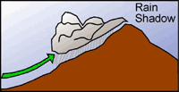 Orographic
uplift occurs when air is forced upward over a topographic barrier. If the
barrier is tall enough, the air parcel is forced upward to the lifting condensation
level where clouds are formed and precipitation may occur. Depending
on conditions, air parcels can be forced back down on the lee side of mountains
(warming and drying as they sink and compress) or can continue to rise, forming
cumulus clouds. In mountainous regions this often results in a rain
shadow. When clouds form over western Oregon and Washington, for instance,
they produce copious amounts of precipitation as the prevailing winds forced
them up and over the western side of the Cascade Range, leaving them dry on
the eastern side of the mountains. The dry areas of central Oregon and Washington
are in the rain shadow of the Cascade Range.
Orographic
uplift occurs when air is forced upward over a topographic barrier. If the
barrier is tall enough, the air parcel is forced upward to the lifting condensation
level where clouds are formed and precipitation may occur. Depending
on conditions, air parcels can be forced back down on the lee side of mountains
(warming and drying as they sink and compress) or can continue to rise, forming
cumulus clouds. In mountainous regions this often results in a rain
shadow. When clouds form over western Oregon and Washington, for instance,
they produce copious amounts of precipitation as the prevailing winds forced
them up and over the western side of the Cascade Range, leaving them dry on
the eastern side of the mountains. The dry areas of central Oregon and Washington
are in the rain shadow of the Cascade Range.
Lenticular clouds
and standing wave clouds are formed by topography. These clouds are associated
with mountain ranges. Rotor clouds can form in standing wave clouds.
These are very dangerous in the world of aviation due to the presence of wind
shear.
 Just
as mountain ranges influence cloud formation by mechanical lifting, widespread
convergence of air masses also forces air upward causing cloud formation. Low-pressure
systems are associated with converging air. The presence of a low-pressure
system is normally associated with extensive clouds and precipitation.
Just
as mountain ranges influence cloud formation by mechanical lifting, widespread
convergence of air masses also forces air upward causing cloud formation. Low-pressure
systems are associated with converging air. The presence of a low-pressure
system is normally associated with extensive clouds and precipitation.
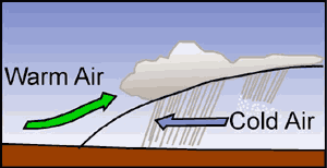
The gradual Iifting of
stable air as a warm front passes can cause formation of stratus clouds over
hundreds, even thousands of square miles. Cold fronts are much steeper and as
a result, air is forced to rise more abruptly. Cold fronts are associated with
instability and cumuliform clouds.
Clouds often change form.
A temperature change within a cloud may cause this. Clouds are good absorbers
of infrared radiation. Usually the tops cool rapidly due to increased radiation
and bottoms warm due to increased absorption. This leads to instability, convection,
and in turn, to a change in cloud form.
Illustrations by Kim Gardner,
2002.